دوتنه:Somalia Numbered Regions.png
د همدې ليدنې کچه: ۴۸۰ × ۶۰۰ پېکسل. نورې ژورليدنې: ۱۹۲ × ۲۴۰ پېکسل | ۵۱۲ × ۶۴۰ پېکسل.
اصلي دوتنه (۵۱۲ × ۶۴۰ پېکسل, د دوتنې کچه: ۲۰ کيلوبايټ, MIME بڼه: image/png)
| څرگندونه |
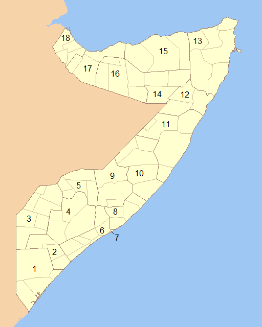
English: Blank map of Somalia showing the regions (numbered) and districts in detail together. 1- Lower Juba 2- Middle Juba 3- Gedo 4- Bay 5- Bakool 6- Lower Shabele 7- Banaadir 8- Middle Shabele 9- Hiiraan 10- Galguduud 11- Mudug 12- Nugaal 13- Bari 14- Sool 15- Sanaag 16- Togdheer 17- Woqooyi Galbeed 18- Awdal |
||
| نېټه | |||
| سرچينه | Modified File:Somalia Regions and Districts.png to create image | ||
| ليکوال | Wiz9999 | ||
| اجازه (دا دوتنه بيا کارول) |
|
||
| نورې بڼې | File:Somalia Regions and Districts.png |
د دوتنې پېښليک
په يوې نېټې/يوه وخت وټوکۍ چې د هماغه وخت او نېټې دوتنه چې څنگه ښکارېده هماغسې درښکاره شي.
| نېټه/وخت | بټنوک | ډډې | کارن | تبصره | |
|---|---|---|---|---|---|
| اوسنی | ۰۰:۱۳, ۶ جون ۲۰۰۹ | | ۵۱۲ × ۶۴۰ (۲۰ کيلوبايټ) | Wiz9999 | {{Information |Description={{en|1=Blank map of Somalia showing the regions (numbered) and districts in detail together.}} |Source=Modified File:Somalia Regions and Districts.png to create image |Author=Wiz9999 |Date=2009-06-05 |Permi |
د دوتنې کارېدنه
دا لاندينی مخ د همدې دوتنې سره تړنې لري:
د نړېوالې دوتنې کارېدنه
همدا دوتنه لاندينۍ نورې ويکي گانې کاروي:
- په als.wikipedia.org کارونې
- په ar.wikipedia.org کارونې
- په azb.wikipedia.org کارونې
- په bg.wikipedia.org کارونې
- په bs.wikipedia.org کارونې
- په da.wikipedia.org کارونې
- په de.wikipedia.org کارونې
- په el.wikipedia.org کارونې
- په en.wikipedia.org کارونې
- په es.wikipedia.org کارونې
- په eu.wikipedia.org کارونې
- په fa.wikipedia.org کارونې
- په is.wikipedia.org کارونې
- په it.wikipedia.org کارونې
- په ko.wikipedia.org کارونې
- په li.wikipedia.org کارونې
- په mk.wikipedia.org کارونې
- په mzn.wikipedia.org کارونې
- په no.wikipedia.org کارونې
- په pl.wikipedia.org کارونې
- په pt.wikipedia.org کارونې
- په ro.wikipedia.org کارونې
- په ru.wikipedia.org کارونې
- په so.wikipedia.org کارونې
- په trv.wikipedia.org کارونې
- په tr.wikipedia.org کارونې
- په ur.wikipedia.org کارونې
- په zh-classical.wikipedia.org کارونې
- په zh.wikipedia.org کارونې