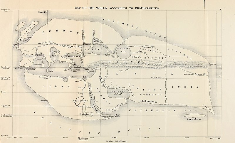
دوتنه:Mappa di Eratostene.jpg

د همدې ليدنې کچه: ۸۰۰ × ۴۸۷ پېکسل. نورې ژورليدنې: ۳۲۰ × ۱۹۵ پېکسل | ۶۴۰ × ۳۹۰ پېکسل | ۱٬۰۲۴ × ۶۲۳ پېکسل | ۱٬۲۸۰ × ۷۷۹ پېکسل | ۲٬۵۶۰ × ۱٬۵۵۹ پېکسل | ۵٬۰۸۵ × ۳٬۰۹۶ پېکسل.
اصلي دوتنه (۵٬۰۸۵ × ۳٬۰۹۶ پېکسل, د دوتنې کچه: ۲٫۳۷ مېگابايټ, MIME بڼه: image/jpeg)
د دوتنې پېښليک
په يوې نېټې/يوه وخت وټوکۍ چې د هماغه وخت او نېټې دوتنه چې څنگه ښکارېده هماغسې درښکاره شي.
| نېټه/وخت | بټنوک | ډډې | کارن | تبصره | |
|---|---|---|---|---|---|
| اوسنی | ۱۴:۵۱, ۵ جولای ۲۰۲۰ |  | ۵٬۰۸۵ × ۳٬۰۹۶ (۲٫۳۷ مېگابايټ) | Sette-quattro | Higher resolution version, from https://archive.org/details/historyofancient00bunb/page/n720/mode/2up |
| ۱۹:۱۲, ۲۴ جون ۲۰۰۷ |  | ۱٬۰۴۰ × ۶۱۱ (۱۴۹ کيلوبايټ) | TcfkaPanairjdde | Mappa di Eratostene, da en.wiki en:Iran.jpg La mappa è tratta da: * Bunbury, E.H., ''A History of Ancient Geography among the Greeks and Romans from the Earliest Ages till the Fall of the Roman Empire''. London: John Murray, 1883. {{PD-Art}} |
د دوتنې کارېدنه
دا لاندينی مخ د همدې دوتنې سره تړنې لري:
د نړېوالې دوتنې کارېدنه
همدا دوتنه لاندينۍ نورې ويکي گانې کاروي:
- په af.wikipedia.org کارونې
- په ar.wikipedia.org کارونې
- په az.wikipedia.org کارونې
- په be-tarask.wikipedia.org کارونې
- په bs.wikipedia.org کارونې
- په ca.wikipedia.org کارونې
- په ceb.wikipedia.org کارونې
- په cs.wikipedia.org کارونې
- په de.wikipedia.org کارونې
- په diq.wikipedia.org کارونې
- په el.wikipedia.org کارونې
- په en.wikipedia.org کارونې
- Alexander the Great
- Eratosthenes
- Seleucus I Nicator
- Persian Gulf naming dispute
- Taprobana
- Name of Iran
- Early world maps
- History of the Indo-Greek Kingdom
- User:Campstriker
- Sources of Indo-Greek history
- User:MinisterForBadTimes/Themistocles
- Homonoia
- Travel in classical antiquity
- User talk:Mdd/History of technical drawing
- User:Falcaorib
- په es.wikipedia.org کارونې
- په eu.wikipedia.org کارونې
- په fa.wikipedia.org کارونې
د دې دوتنې نورې نړېوالې کارېدنې کتل.


