دوتنه:Countries driving on the left or right.svg

Size of this PNG preview of this SVG file: ۸۰۰ × ۴۰۶ پېکسل. نورې ژورليدنې: ۳۲۰ × ۱۶۲ پېکسل | ۶۴۰ × ۳۲۵ پېکسل | ۱٬۰۲۴ × ۵۲۰ پېکسل | ۱٬۲۸۰ × ۶۵۰ پېکسل | ۲٬۵۶۰ × ۱٬۳۰۰ پېکسل | ۲٬۷۵۴ × ۱٬۳۹۸ پېکسل.
اصلي دوتنه (SVG دوتنه، نومېنلي ۲٬۷۵۴ × ۱٬۳۹۸ پېکسل، د دوتنې کچه: ۱٫۱ مېگابايټ)
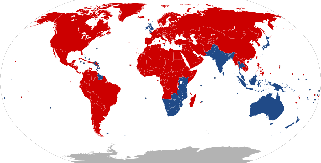
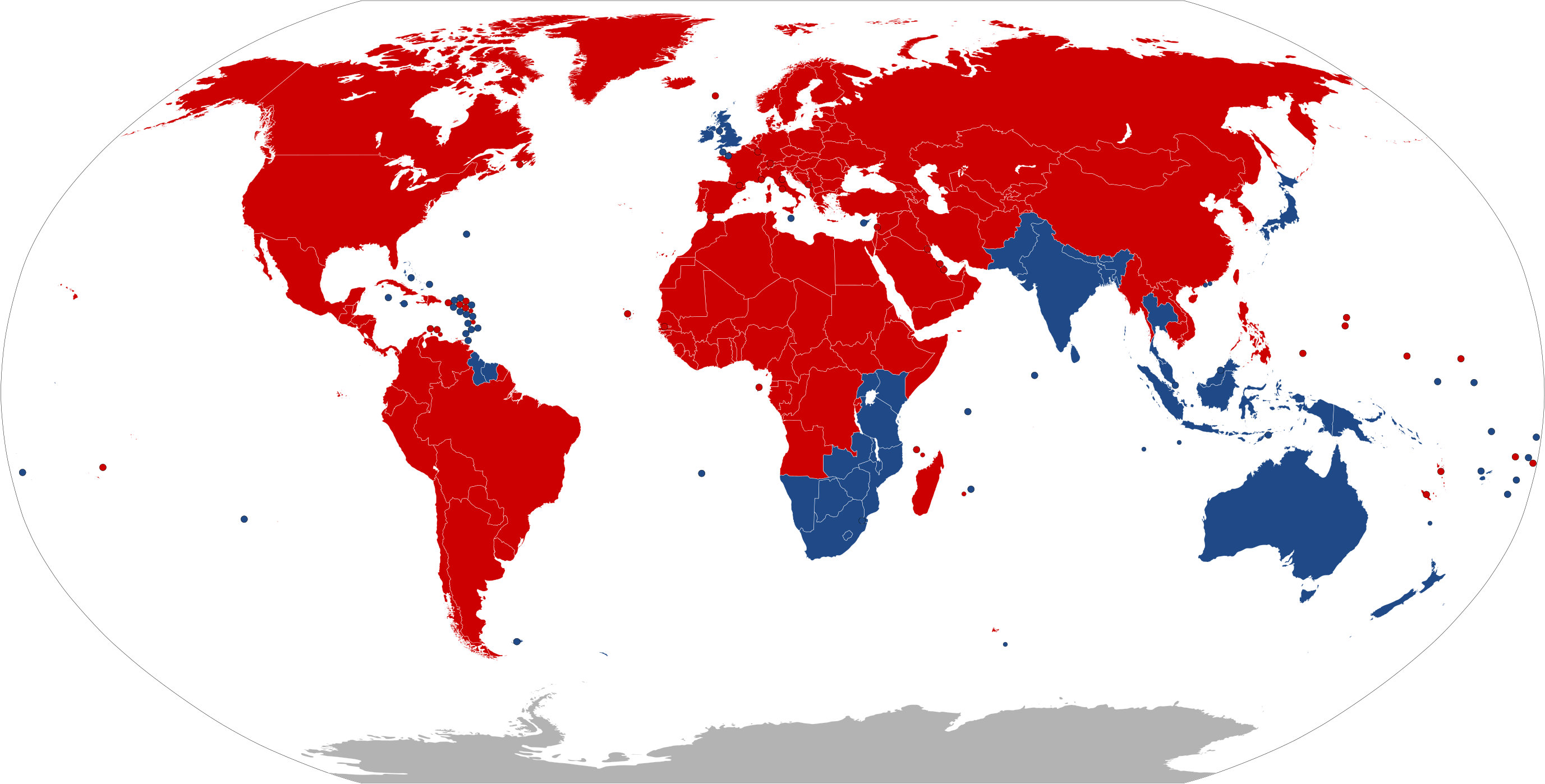
| Colour | Explanation | |
|---|---|---|
| ↓↑ | Drives on right | |
| ↑↓ | Drives on left | |
| ? | No Information |
| څرگندونه |
Deutsch: Die Karte zeigt, in welchen Ländern der Erde Rechtsverkehr und in welchen Linksverkehr besteht.
Bosanski: Mapa pokazuje u kojim državama se vozi na desnoj strani ulice, a u kojim se vozi na lijevoj strani.
Català: Mapa que mostra en quins països es conduïx pel costat dret de la carretera, i en quins es conduïx pel costat esquerre.
English: A map indicating which countries drive on the right side of the road, and which drive on the left side.
Esperanto: Mapo indikanta, en kiuj landoj oni veturas sur la dekstra flanko de la strato, kaj en kiuj oni veturas sur la maldekstra flanko.
Español: Mapa que indica en cuáles países se maneja por el lado derecho o el lado izquierdo de la calle.
Bahasa Indonesia: Peta yang menunjukkan negara mana yang mengemudi di sisi kanan jalan, dan mana yang mengemudi di sisi kiri.
Íslenska: Kort sem sýnir hver lönd nota hægri umferð, og hver nota vinstri umferð.
Italiano: Mappa che indica in quali paesi si guida sul lato destro e in quali sul lato sinistro della strada.
日本語: 道路の右側を通行する国か左側を通行する国かを示した地図。
Nederlands: Deze kaart geeft aan in welke landen ter Wereld er Rechts en in welke er Links gereden wordt.
Polski: Mapa pokazująca, w jakich krajach jeździ się po prawej stronie drogi, a w których po lewej.
Русский: Карта с указанием, в каких странах ездят по правой стороне дороги и в каких ездят по левой стороне.
Türkçe: Trafiğin yolun sağ tarafından ve sol tarafından aktığını belirten ülkelerin haritası.
中文:显示世界上靠右行驶和靠左行驶的国家。 |
||
| نېټه | |||
| سرچينه |
Created by bdesham in Inkscape from BlankMap-World6.svg, using information from Sens de circulation.png. This W3C-unspecified vector image was created with Inkscape . |
||
| ليکوال | Benjamin D. Esham (bdesham) | ||
| اجازه (دا دوتنه بيا کارول) |
As a courtesy (but not a requirement), please e-mail me or leave a note on my talk page if you use this image outside of Wikipedia. Thanks! Benjamin D. Esham, the copyright holder of this work, hereby publishes it under the following license:
|
د دوتنې پېښليک
په يوې نېټې/يوه وخت وټوکۍ چې د هماغه وخت او نېټې دوتنه چې څنگه ښکارېده هماغسې درښکاره شي.
| نېټه/وخت | بټنوک | ډډې | کارن | تبصره | |
|---|---|---|---|---|---|
| اوسنی | ۱۹:۴۵, ۲۶ مې ۲۰۲۰ | | ۲٬۷۵۴ × ۱٬۳۹۸ (۱٫۱ مېگابايټ) | Xophe84 | antarctica |
| ۲۱:۵۱, ۲۶ اپرېل ۲۰۲۰ |  | ۲٬۷۵۴ × ۱٬۳۹۸ (۱٫۰۶ مېگابايټ) | Hippymoose17 | Reverted to version as of 03:05, 23 April 2020 (UTC) | |
| ۲۱:۵۱, ۲۶ اپرېل ۲۰۲۰ |  | ۲٬۵۰۰ × ۱٬۲۶۹ (۷۵ کيلوبايټ) | Hippymoose17 | ... | |
| ۰۳:۰۵, ۲۳ اپرېل ۲۰۲۰ |  | ۲٬۷۵۴ × ۱٬۳۹۸ (۱٫۰۶ مېگابايټ) | Numberguy6 | Fixed Cook Islands and Tokelau | |
| ۱۷:۴۶, ۲۰ اکتوبر ۲۰۱۹ |  | ۲٬۷۵۴ × ۱٬۳۹۸ (۱٫۰۶ مېگابايټ) | Bdesham | Replaced “Swaziland” with “Eswatini” and “The Former Yugoslav Republic of North Macedonia” with “North Macedonia.” | |
| ۰۱:۱۲, ۴ اپرېل ۲۰۱۹ |  | ۲٬۷۵۴ × ۱٬۳۹۸ (۱٫۰۶ مېگابايټ) | Newfraferz87 | Fixed Bulgaria & Bangladesh | |
| ۱۱:۳۶, ۳ اپرېل ۲۰۱۹ |  | ۹۴۰ × ۴۷۷ (۱٫۶۳ مېگابايټ) | BrightRaven | Reverted to version as of 09:23, 2 April 2019 (UTC) Bulgaria does not drive on the left | |
| ۱۱:۰۷, ۳ اپرېل ۲۰۱۹ |  | ۲٬۷۵۴ × ۱٬۳۹۸ (۱٫۰۶ مېگابايټ) | Newfraferz87 | No explanation given for earlier reversion. Stick to optimized file | |
| ۰۹:۲۳, ۲ اپرېل ۲۰۱۹ |  | ۹۴۰ × ۴۷۷ (۱٫۶۳ مېگابايټ) | Nedops | Reverted to version as of 20:07, 2 September 2016 (UTC) | |
| ۰۹:۰۳, ۲ اپرېل ۲۰۱۹ |  | ۲٬۷۵۴ × ۱٬۳۹۸ (۱٫۰۶ مېگابايټ) | Newfraferz87 | April 1 template |
د دوتنې کارېدنه
دا 3 لانديني مخونه د همدې دوتنې سره تړنې لري:
د نړېوالې دوتنې کارېدنه
همدا دوتنه لاندينۍ نورې ويکي گانې کاروي:
- په ar.wikipedia.org کارونې
- په arz.wikipedia.org کارونې
- په azb.wikipedia.org کارونې
- په az.wikipedia.org کارونې
- په bn.wikipedia.org کارونې
- په ca.wikipedia.org کارونې
- په ckb.wikipedia.org کارونې
- په cs.wikipedia.org کارونې
- په cv.wikipedia.org کارونې
- په da.wikipedia.org کارونې
- په de.wikipedia.org کارونې
- په el.wikipedia.org کارونې
- په en.wikipedia.org کارونې
- په en.wikivoyage.org کارونې
- په eo.wikipedia.org کارونې
- په es.wikipedia.org کارونې
- په et.wikipedia.org کارونې
- په eu.wikipedia.org کارونې
- په fa.wikipedia.org کارونې
- په fi.wikipedia.org کارونې
- په fr.wikipedia.org کارونې
- په fr.wikibooks.org کارونې
- په fr.wikivoyage.org کارونې
- په fy.wikipedia.org کارونې
- په he.wikipedia.org کارونې
- په he.wikivoyage.org کارونې
- په hi.wikipedia.org کارونې
- په hr.wikipedia.org کارونې
- په hu.wikipedia.org کارونې
- په id.wikipedia.org کارونې
- په is.wikipedia.org کارونې
- په it.wikipedia.org کارونې
- په ja.wikipedia.org کارونې
د دې دوتنې نورې نړېوالې کارېدنې کتل.