کينډۍ:Infobox map/doc
This template will generate an error message and garbage if it is transcluded with {{{map}}} undefined. This reduces expansion depth which is critical in many infoboxes that transclude this template. |
This helper template provides a way to display a map in an Infobox. Optionally a location marker can be included.
Usage
سمولParameter descriptions
سمول| Field name | Description |
|---|---|
map |
The name of the map to be displayed. This is the only required parameter. |
map_width |
The width of the map image to be displayed. For example, map_width=220 and not map_width=220px.
|
default_width |
When this template is used in another template, e.g. an infobox, the default width of the map image preferred by the infobox should be specified here. For example, map_width=220. When used with location maps, this value may be modified by a certain value if specified in the location map template. The default value is 220px.
|
relief |
Selects a relief map when assigned any value. This only works when the geographical coordinates method is used and then only for a few maps. See Map display methods. |
map_alt |
Alt text for the map. A visually impaired reader who uses a screen reader will have access to this text. See WP:ALT. |
map_caption |
The caption that appears below the map if one is required. |
mark |
The image file that will be used to mark the location on the map. The default is Red pog.svg. See below. |
mark_width |
The width of the marker image to be displayed. For example, mark_width=8 and not mark_width=8px. The default width is 8px.
|
label |
A text message that will be displayed next to the marker. |
label_position |
The position of a label with respect to the marker. Valid values are left, right, top, bottom and none.
|
background |
The background color for the label. If no value is assigned the background will be transparent. See Web colors. |
coordinates |
The coordinates of the location in {{Coord}} format. While not recommended, if you want to waste time you can also enter them in decimal degrees (e.g. 48.067°N 12.863°E). You shouldn't need to, though.
|
latlong |
Specifies the latitude and longitude of the location when the geographical coordinates method is used. This value may be specified as a signed decimal degree. |
lat_deglat_minlat_seclat_dir
|
Specifies the latitude and longitude of the location when the geographical coordinates method is used. This value may be specified in dms+hemisphere format. |
Map display methods
سمولThere are two methods which can display a map. These examples use {{Infobox park}} which uses this template as a back end.
Display a marker on a map using a template and geographic coordinates
سمولA marker can be superimposed on a map using one of a set of special map templates. To display a marker, the geographic coordinates must be specified using the {{Coord}} template inside the |coordinates= parameter. See the documentation for {{Location map}}. The parameters for this template map to a subset of the parameters used by {{Location map}}. A map template can be found using these sources:
- List of templates – Many of the listed items are redirects and a few templates may not function as expected.
- Category:Location map templates - templates sorted by category.
- Special:WhatLinksHere/Template:Location map/Info – a search that might help.
- Special:PrefixIndex/Module:Location map/data/ – another search that might help.
- Special:Prefixindex/Template:Location map – another search that might help.
All of the names begin with the words "Location map" followed by the area covered. The value you need to specify is the area name. The map template for Canada is Location map/data/Canada. In this case specify |map=Canada.
{{Infobox park
| name = Four Corners, Canada
| map = Canada
| map_caption = Example using geographic coordinates
| coordinates = {{coord|60|N|102|W|display=inline <!-- for documentation page only - not general practice --> }}
}}
By default, {{Coord}} displays in the infobox only in the page title. Parameter |display=inline,title can be added to make the coordinates display at the top of the page as well.
Legacy parameters
سمولAlthough deprecated in infoboxes in August 2016, it is still possible in this template to use the |lat_d=, |lat_m=, |lat_s=, |lat_NS=, |long_d=, |long_m=, |long_s= and |long_NS= parameters (for latitude degrees, minutes, seconds and direction; and longitude degrees, minutes, seconds and direction respectively).
Display any image
سمولAn image can be displayed without a location mark.
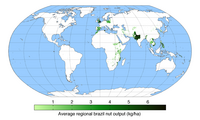
| Average regional brazil nut output (kg/ha) | |
|---|---|
 |
{{Infobox
| above =
| image2 = {{Infobox map
           | map         = Braziloutput.png
           | map_alt     = A world map showing regions that produce Brazil nuts.
           | map_caption =
           | map_width   = 200
           }}
}}
Marks
سمولA mark can be any image file. The default mark is Red pog.svg and it works well because it is easy to pick up visually on most maps. Some examples are below. Click on an image to see the file description page.
See Location markers for other examples. Currently, using mark_width=n for n > 8 is not advised when a label is specified.
Geographical coordinates
سمولThe template {{Infobox coord}} can be used to display coordinates entered using the method discussed above.
TemplateData
سمولTemplateData for Infobox map
Tracking category
سمول- Category:Pages using Template:Infobox map needing attention (۰)
- Category:Pages using infobox map without location map (۵)
Templates using this template
سمول- {{Infobox cave}}
- {{Infobox climbing area}}
- {{Infobox climbing route}}
- {{Infobox forest}}
- {{Infobox glacier}}
- {{Infobox islands}}
- {{Infobox landform}}
- {{Infobox mountain}}
- {{Infobox mountain pass}}
- {{Infobox park}}
- {{Infobox protected area}}
- {{Infobox protected area/Wikidata}}
- {{Infobox Spanish missions in the Americas}}
- {{Infobox spring}}
- {{Infobox terrestrial impact site}}
- {{Infobox valley}}
- {{Infobox waterfall}}
See also
سمول- {{Location map}}