دوتنه:Tatar03.png
د همدې ليدنې کچه: ۸۰۰ × ۵۵۹ پېکسل. نورې ژورليدنې: ۳۲۰ × ۲۲۴ پېکسل | ۶۴۰ × ۴۴۷ پېکسل | ۹۴۰ × ۶۵۷ پېکسل.
اصلي دوتنه (۹۴۰ × ۶۵۷ پېکسل, د دوتنې کچه: ۵۳ کيلوبايټ, MIME بڼه: image/png)
لنډيز
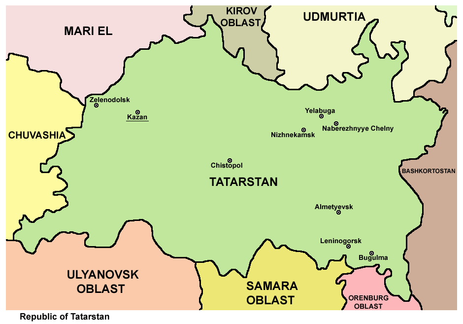
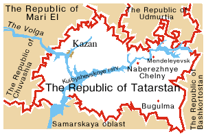
- Map of the Republic of Tatarstan.
Source and license

|
This map has been uploaded by Electionworld from en.wikipedia.org to enable the |
Map made by PANONIAN
| This work has been released into the public domain by its author, PANONIAN. This applies worldwide. In some countries this may not be legally possible; if so: |
References
Maps from external links:
- http://www.marriage-4u.com/StylePics/Services/maps/big/map-of-kazan-tatarstan-russia.jpg
- http://kartoman.ru/wp-content/uploads/2011/04/karta_tatarstana.jpg
- http://www.tamsa-tatarstan.com/eng/tatarstan/Tatarstan_location.jpg
- https://www.usrbc.org/pics/Image/Russian%20Regions/Tatarstan/map_tatarstan.jpg
- http://www.canton.edu/international/images/tatarstan.jpg
- http://map-site.narod.ru/tatarstan-1.jpg
- http://1997-2011.tatarstan.ru/images/map_fiz.jpg
- http://www.mapzones.com/citymap/russia/tatarstan/tatarstan.jpg
- http://www.rdaward.org/map/4p.jpg
- http://1997-2011.tatarstan.ru/images/reg_mape.gif
- http://openbudget.karelia.ru/budnord/russian/volga/tatarstan-republic/images/karta_tatarstan.jpg
- http://3.bp.blogspot.com/_85ACsZ2kALY/TEsBVP3RDII/AAAAAAAAHL8/xKV0Owl_EvY/s1600/KartaTatarstan.jpg
- http://minstroy.tatarstan.ru/rus/file/pub/pub_38154.jpg
- http://kazan.eparhia.ru/www/imgs/map.gif
- http://files.vector-images.com/clipart/tatarstan_map.gif
- http://2.bp.blogspot.com/-Qliz_nf4MuU/TsH1N0d7QHI/AAAAAAAAIVk/xrkYygfBjxs/s1600/Tatarstan%2B-%2BBashkortstan.jpg
- http://map.rin.ru/maps_e/Tatar.gif
- http://nd01.jxs.cz/092/027/40eaf2b2c9_18229649_o2.jpg
- http://www.16.mchs.gov.ru/upload/images/KartaTatar.jpg
Largest cities and towns in Tatarstan:
د دوتنې پېښليک
په يوې نېټې/يوه وخت وټوکۍ چې د هماغه وخت او نېټې دوتنه چې څنگه ښکارېده هماغسې درښکاره شي.
| نېټه/وخت | بټنوک | ډډې | کارن | تبصره | |
|---|---|---|---|---|---|
| اوسنی | ۱۳:۰۷, ۱ جون ۲۰۱۲ | | ۹۴۰ × ۶۵۷ (۵۳ کيلوبايټ) | PANONIAN | {{Information |Description ={{en|1=improved version}} |Source =improved version |Author =improved version |Date = |Permission = |other_versions = }} |
| ۱۶:۰۷, ۲۹ ډيسمبر ۲۰۰۶ |  | ۷۷۰ × ۵۲۲ (۲۷ کيلوبايټ) | Electionworld | {{ew|en|PANONIAN}} Map made by PANONIAN {{PD-user|PANONIAN}} Category:Maps of the Russian republics |
د دوتنې کارېدنه
دا لاندينی مخ د همدې دوتنې سره تړنې لري:
د نړېوالې دوتنې کارېدنه
همدا دوتنه لاندينۍ نورې ويکي گانې کاروي:
- په ace.wikipedia.org کارونې
- په ast.wikipedia.org کارونې
- په az.wikipedia.org کارونې
- په ba.wikipedia.org کارونې
- په be-tarask.wikipedia.org کارونې
- په bn.wikipedia.org کارونې
- په bs.wikipedia.org کارونې
- په bxr.wikipedia.org کارونې
- په ckb.wikipedia.org کارونې
- په crh.wikipedia.org کارونې
- په cs.wikipedia.org کارونې
- په cv.wikipedia.org کارونې
- په da.wikipedia.org کارونې
- په diq.wikipedia.org کارونې
- په el.wikipedia.org کارونې
- په en.wikipedia.org کارونې
- په eo.wikipedia.org کارونې
- په es.wikipedia.org کارونې
- په eu.wikipedia.org کارونې
- په frr.wikipedia.org کارونې
- په fr.wikipedia.org کارونې
- په gag.wikipedia.org کارونې
- په ga.wikipedia.org کارونې
- په gv.wikipedia.org کارونې
- په hi.wikipedia.org کارونې
- په hr.wikipedia.org کارونې
- په id.wikipedia.org کارونې
- په is.wikipedia.org کارونې
- په it.wikipedia.org کارونې
- په ja.wikipedia.org کارونې
- په kaa.wikipedia.org کارونې
- په kk.wikipedia.org کارونې
- په koi.wikipedia.org کارونې
- په ko.wikipedia.org کارونې
- په la.wikipedia.org کارونې
- په lez.wikipedia.org کارونې
د دې دوتنې نورې نړېوالې کارېدنې کتل.