دوتنه:SakastanMap.jpg

د همدې ليدنې کچه: ۷۳۳ × ۵۹۹ پېکسل. نورې ژورليدنې: ۲۹۴ × ۲۴۰ پېکسل | ۵۸۷ × ۴۸۰ پېکسل | ۹۳۹ × ۷۶۸ پېکسل | ۱٬۲۵۲ × ۱٬۰۲۴ پېکسل | ۱٬۳۵۶ × ۱٬۱۰۹ پېکسل.
اصلي دوتنه (۱٬۳۵۶ × ۱٬۱۰۹ پېکسل, د دوتنې کچه: ۲۵۸ کيلوبايټ, MIME بڼه: image/jpeg)

|
This historical map image could be re-created using vector graphics as an SVG file. This has several advantages; see Commons:Media for cleanup for more information. If an SVG form of this image is available, please upload it and afterwards replace this template with
{{vector version available|new image name}}.
It is recommended to name the SVG file “SakastanMap.svg”—then the template Vector version available (or Vva) does not need the new image name parameter. |


لنډيز
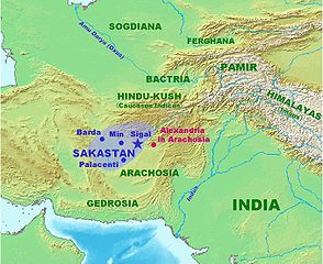
| څرگندونه | Map of Sakastan circa 100 BCE. Own work. |
| نېټه | ۲۱ جنوري ۲۰۰۷ (original upload date) |
| سرچينه | No machine-readable source provided. Own work assumed (based on copyright claims). |
| ليکوال | No machine-readable author provided. World Imaging assumed (based on copyright claims). |
منښتليک:
| I, the copyright holder of this work, release this work into the public domain. This applies worldwide. In some countries this may not be legally possible; if so: I grant anyone the right to use this work for any purpose, without any conditions, unless such conditions are required by law. |
د دوتنې پېښليک
په يوې نېټې/يوه وخت وټوکۍ چې د هماغه وخت او نېټې دوتنه چې څنگه ښکارېده هماغسې درښکاره شي.
| نېټه/وخت | بټنوک | ډډې | کارن | تبصره | |
|---|---|---|---|---|---|
| اوسنی | ۲۱:۲۲, ۲۱ جنوري ۲۰۰۷ | | ۱٬۳۵۶ × ۱٬۱۰۹ (۲۵۸ کيلوبايټ) | World Imaging | More precise map, with Arachosia. |
| ۲۱:۰۵, ۲۱ جنوري ۲۰۰۷ |  | ۱٬۳۵۳ × ۱٬۱۱۲ (۲۶۰ کيلوبايټ) | World Imaging | Map of Sakastan circa 100 BCE. Own work. |
د دوتنې کارېدنه
داسې هېڅ کوم مخ نه شته چې د دغې دوتنې سره تړنې ولري.
د نړېوالې دوتنې کارېدنه
همدا دوتنه لاندينۍ نورې ويکي گانې کاروي:
- په af.wikipedia.org کارونې
- په arz.wikipedia.org کارونې
- په bcl.wikipedia.org کارونې
- په bn.wikipedia.org کارونې
- په ca.wikipedia.org کارونې
- په cs.wikipedia.org کارونې
- په de.wikipedia.org کارونې
- په diq.wikipedia.org کارونې
- په en.wikipedia.org کارونې
- په eo.wikipedia.org کارونې
- په es.wikipedia.org کارونې
- په et.wikipedia.org کارونې
- په fa.wikipedia.org کارونې
- په hu.wikipedia.org کارونې
- په incubator.wikimedia.org کارونې
- په it.wikipedia.org کارونې
- په ka.wikipedia.org کارونې
- په ml.wikipedia.org کارونې
- په ne.wikipedia.org کارونې
- په nl.wikipedia.org کارونې
- په pa.wikipedia.org کارونې
- په pl.wikipedia.org کارونې
- په pl.wiktionary.org کارونې
- په ro.wikipedia.org کارونې
- په ru.wikipedia.org کارونې
- په sr.wikipedia.org کارونې
- په sv.wikipedia.org کارونې
- په sw.wikipedia.org کارونې
د دې دوتنې نورې نړېوالې کارېدنې کتل.