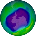
دوتنه:NASA and NOAA Announce Ozone Hole is a Double Record Breaker.png

د همدې ليدنې کچه: ۶۰۰ × ۶۰۰ پېکسل. نورې ژورليدنې: ۲۴۰ × ۲۴۰ پېکسل | ۴۸۰ × ۴۸۰ پېکسل | ۷۱۶ × ۷۱۶ پېکسل.
اصلي دوتنه (۷۱۶ × ۷۱۶ پېکسل, د دوتنې کچه: ۴۱۱ کيلوبايټ, MIME بڼه: image/png)
د دوتنې پېښليک
په يوې نېټې/يوه وخت وټوکۍ چې د هماغه وخت او نېټې دوتنه چې څنگه ښکارېده هماغسې درښکاره شي.
| نېټه/وخت | بټنوک | ډډې | کارن | تبصره | |
|---|---|---|---|---|---|
| اوسنی | ۰۲:۴۰, ۱۸ فبروري ۲۰۱۲ |  | ۷۱۶ × ۷۱۶ (۴۱۱ کيلوبايټ) | Ras67 | JPEG artifacts mitigated and background removed |
| ۲۰:۲۹, ۲۸ اگسټ ۲۰۰۷ |  | ۷۱۶ × ۷۱۶ (۴۰۹ کيلوبايټ) | Nils Simon |
د دوتنې کارېدنه
دا لاندينی مخ د همدې دوتنې سره تړنې لري:
د نړېوالې دوتنې کارېدنه
همدا دوتنه لاندينۍ نورې ويکي گانې کاروي:
- په af.wikipedia.org کارونې
- په als.wikipedia.org کارونې
- په ar.wikipedia.org کارونې
- په az.wikipedia.org کارونې
- په be.wikipedia.org کارونې
- په bg.wikipedia.org کارونې
- په bn.wikipedia.org کارونې
- په bs.wikipedia.org کارونې
- په ca.wikipedia.org کارونې
- په cs.wikipedia.org کارونې
- په cv.wikipedia.org کارونې
- په de.wikipedia.org کارونې
- په de.wikibooks.org کارونې
- په el.wikipedia.org کارونې
- په en.wikipedia.org کارونې
- په en.wikibooks.org کارونې
- په en.wikinews.org کارونې
- په es.wikipedia.org کارونې
د دې دوتنې نورې نړېوالې کارېدنې کتل.

