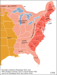
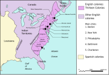
دوتنه:Map of territorial growth 1775.jpg

د همدې ليدنې کچه: ۴۵۶ × ۶۰۰ پېکسل. نورې ژورليدنې: ۱۸۲ × ۲۴۰ پېکسل | ۵۷۰ × ۷۵۰ پېکسل.
اصلي دوتنه (۵۷۰ × ۷۵۰ پېکسل, د دوتنې کچه: ۱۷۲ کيلوبايټ, MIME بڼه: image/jpeg)
د دوتنې پېښليک
په يوې نېټې/يوه وخت وټوکۍ چې د هماغه وخت او نېټې دوتنه چې څنگه ښکارېده هماغسې درښکاره شي.
| نېټه/وخت | بټنوک | ډډې | کارن | تبصره | |
|---|---|---|---|---|---|
| اوسنی | ۰۳:۰۷, ۳۰ مارچ ۲۰۱۳ |  | ۵۷۰ × ۷۵۰ (۱۷۲ کيلوبايټ) | Ras67 | cropped |
| ۰۴:۴۴, ۳ ډيسمبر ۲۰۰۶ |  | ۶۲۰ × ۸۰۰ (۱۲۲ کيلوبايټ) | Dedee73 | The first 13 american colonies | |
| ۲۱:۱۳, ۶ جون ۲۰۰۵ |  | ۶۲۰ × ۸۰۰ (۱۲۲ کيلوبايټ) | Kooma | Map of territorial growth, 1775. From en.wiki. {{PD-USGov-Atlas}} Category:American Revolution |
د دوتنې کارېدنه
داسې هېڅ کوم مخ نه شته چې د دغې دوتنې سره تړنې ولري.
د نړېوالې دوتنې کارېدنه
همدا دوتنه لاندينۍ نورې ويکي گانې کاروي:
- په ar.wikipedia.org کارونې
- په az.wikipedia.org کارونې
- په bg.wikipedia.org کارونې
- په bn.wikipedia.org کارونې
- په ca.wikipedia.org کارونې
- په da.wikipedia.org کارونې
- په el.wikipedia.org کارونې
- په en.wikipedia.org کارونې
- American cuisine
- Empire
- British North America
- History of the United States (1776–1789)
- Timeline of the American Revolution
- Public Land Survey System
- History of Pennsylvania
- Constitutional history of Canada
- Cultural assimilation of Native Americans
- User:Notuncurious/Working/tmp3
- User:Notuncurious/Working/tmp6
- Aboriginal title in the United States
- Aboriginal title statutes in the Thirteen Colonies
- User:Purplebackpack89/SimpleWikipediaHoftheUS
- Talk:United States Declaration of Independence/Archive 8
- George Washington's political evolution
- User:Lodzdeena/ABŞ tarixi (1776–1789)
- User:Lodzdeena/test
- په en.wikibooks.org کارونې
- په en.wikiversity.org کارونې
- په fa.wikipedia.org کارونې
- په fr.wikipedia.org کارونې
- په fr.wikisource.org کارونې
- په gl.wikipedia.org کارونې
- په he.wikipedia.org کارونې
- په hu.wikipedia.org کارونې
د دې دوتنې نورې نړېوالې کارېدنې کتل.


