دوتنه:Helmand districts.png
د همدې ليدنې کچه: ۷۸۶ × ۶۰۰ پېکسل. نورې ژورليدنې: ۳۱۵ × ۲۴۰ پېکسل | ۶۲۹ × ۴۸۰ پېکسل | ۱٬۰۰۰ × ۷۶۳ پېکسل.
اصلي دوتنه (۱٬۰۰۰ × ۷۶۳ پېکسل, د دوتنې کچه: ۳۲ کيلوبايټ, MIME بڼه: image/png)

|
This map image could be re-created using vector graphics as an SVG file. This has several advantages; see Commons:Media for cleanup for more information. If an SVG form of this image is available, please upload it and afterwards replace this template with
{{vector version available|new image name}}.
It is recommended to name the SVG file “Helmand districts.svg”—then the template Vector version available (or Vva) does not need the new image name parameter. |
لنډيز
| څرگندونه |
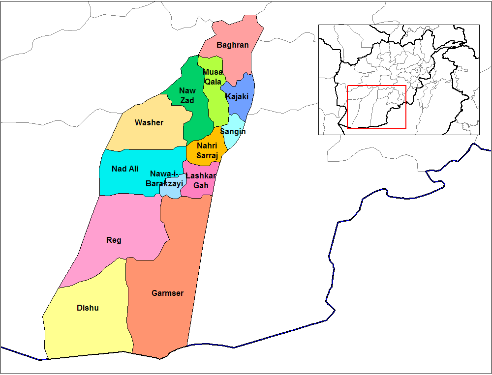
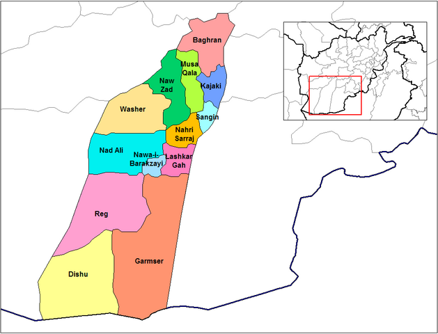
English: Map of the districts of Helmand province of Afghanistan. Created by Rarelibra 19:24, 29 March 2007 (UTC) for public domain use, using MapInfo Professional v8.5 and various mapping resources. |
| نېټه | ۲۹ مارچ ۲۰۰۷ (original upload date) |
| سرچينه | No machine-readable source provided. Own work assumed (based on copyright claims). |
| ليکوال | No machine-readable author provided. Rarelibra assumed (based on copyright claims). |
منښتليک:
| I, the copyright holder of this work, release this work into the public domain. This applies worldwide. In some countries this may not be legally possible; if so: I grant anyone the right to use this work for any purpose, without any conditions, unless such conditions are required by law. |
د دوتنې پېښليک
په يوې نېټې/يوه وخت وټوکۍ چې د هماغه وخت او نېټې دوتنه چې څنگه ښکارېده هماغسې درښکاره شي.
| نېټه/وخت | بټنوک | ډډې | کارن | تبصره | |
|---|---|---|---|---|---|
| اوسنی | ۱۴:۱۰, ۱۵ فبروري ۲۰۲۴ | | ۱٬۰۰۰ × ۷۶۳ (۳۲ کيلوبايټ) | User-duck | Cropped 5 % horizontally, 6 % vertically using CropTool with lossless mode. |
| ۱۴:۰۹, ۱۵ فبروري ۲۰۲۴ |  | ۱٬۰۵۶ × ۸۱۶ (۳۲ کيلوبايټ) | User-duck | Reverted to version as of 19:24, 29 March 2007 (UTC)recrop | |
| ۱۳:۵۳, ۱۵ فبروري ۲۰۲۴ |  | ۱٬۰۰۰ × ۷۶۲ (۳۲ کيلوبايټ) | User-duck | Cropped 5 % horizontally, 7 % vertically using CropTool with lossless mode. | |
| ۱۹:۲۴, ۲۹ مارچ ۲۰۰۷ |  | ۱٬۰۵۶ × ۸۱۶ (۳۲ کيلوبايټ) | Rarelibra | Map of the districts of Helmand province of Afghanistan. Created by ~~~~ for public domain use, using MapInfo Professional v8.5 and various mapping resources. |
د دوتنې کارېدنه
دا 3 لانديني مخونه د همدې دوتنې سره تړنې لري:
د نړېوالې دوتنې کارېدنه
همدا دوتنه لاندينۍ نورې ويکي گانې کاروي:
- په ar.wikipedia.org کارونې
- په bn.wikipedia.org کارونې
- په ca.wikipedia.org کارونې
- په ceb.wikipedia.org کارونې
- په da.wikipedia.org کارونې
- په de.wikipedia.org کارونې
- په en.wikipedia.org کارونې
- په en.wikinews.org کارونې
- په eo.wikipedia.org کارونې
- په es.wikipedia.org کارونې
- په fa.wikipedia.org کارونې
- په fr.wikipedia.org کارونې
- په he.wikipedia.org کارونې
- په hu.wikipedia.org کارونې
- په it.wikipedia.org کارونې
- په it.wikinews.org کارونې
- په ja.wikipedia.org کارونې
- په lt.wikipedia.org کارونې
- په mn.wikipedia.org کارونې
- په ms.wikipedia.org کارونې
- په nl.wikipedia.org کارونې
- په no.wikipedia.org کارونې
- په pl.wikipedia.org کارونې
د دې دوتنې نورې نړېوالې کارېدنې کتل.