دوتنه:Federal subjects of Russia by population dencity.svg

Size of this PNG preview of this SVG file: ۸۰۰ × ۴۳۴ پېکسل. نورې ژورليدنې: ۳۲۰ × ۱۷۳ پېکسل | ۶۴۰ × ۳۴۷ پېکسل | ۱٬۰۲۴ × ۵۵۵ پېکسل | ۱٬۲۸۰ × ۶۹۴ پېکسل | ۲٬۵۶۰ × ۱٬۳۸۸ پېکسل | ۵٬۰۰۰ × ۲٬۷۱۰ پېکسل.
اصلي دوتنه (SVG دوتنه، نومېنلي ۵٬۰۰۰ × ۲٬۷۱۰ پېکسل، د دوتنې کچه: ۲۴۰ کيلوبايټ)
Crimea is Ukraine

|
The boundaries on this map show the de facto situation. This is just one of several different views on the subject (see COM:NPOV). |
لنډيز
| څرگندونه |
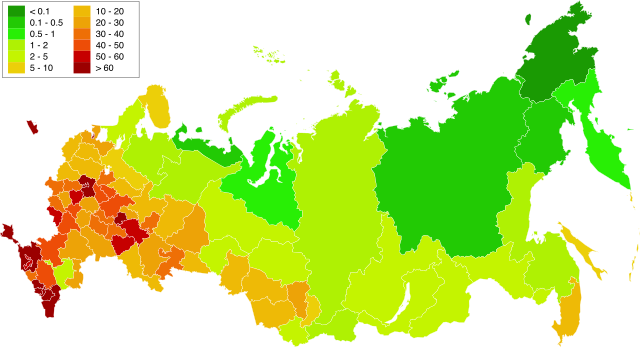
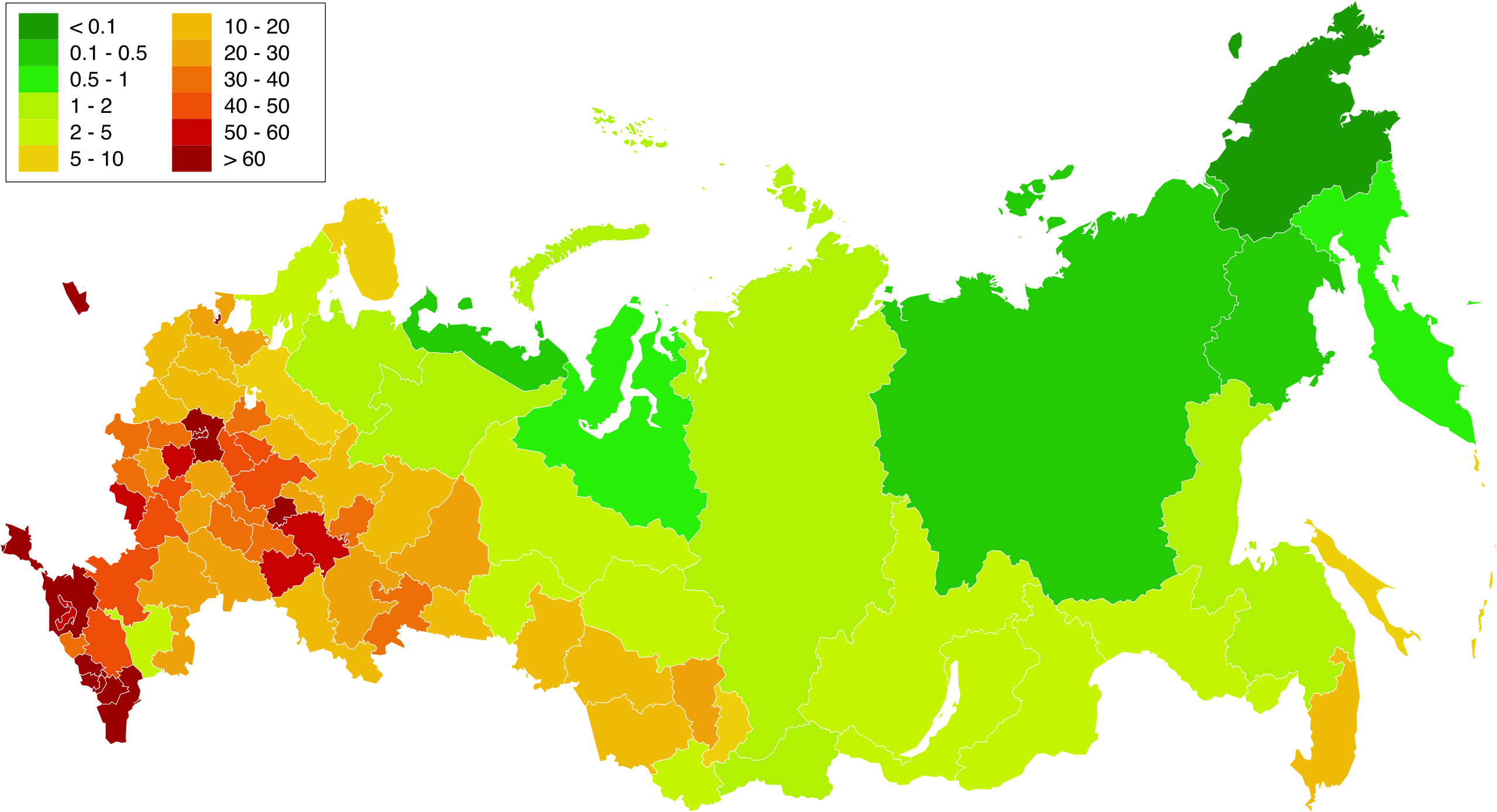
English: Map of population density in the subjects of the Russian Federation. The population density of Arkhangelsk Oblast and Tyumen Oblast was calculated together with the population and area of the respective Autonomous Okrugs belonging to them.
Русский: Карта плотности населения в субъектах Российской Федерации. При расчёте плотностей населения Архангельской и Тюменской области учитывались площади и населения входящих в них автономных округов. |
| نېټه | 1.02.2010 20:39:08 MSK |
| سرچينه | Russia - blank map (2009-01).svg |
| ليکوال | شخصي اثر. Original uploader was Алексей Глушков at ru.wikipedia |
| نورې بڼې |
Other views related to this image
|

.svg)
منښتليک:
| I, the copyright holder of this work, release this work into the public domain. This applies worldwide. In some countries this may not be legally possible; if so: I grant anyone the right to use this work for any purpose, without any conditions, unless such conditions are required by law. |
د دوتنې پېښليک
په يوې نېټې/يوه وخت وټوکۍ چې د هماغه وخت او نېټې دوتنه چې څنگه ښکارېده هماغسې درښکاره شي.
| نېټه/وخت | بټنوک | ډډې | کارن | تبصره | |
|---|---|---|---|---|---|
| اوسنی | ۱۶:۵۸, ۲۰ مارچ ۲۰۱۹ | | ۵٬۰۰۰ × ۲٬۷۱۰ (۲۴۰ کيلوبايټ) | Gajmar | Kaluga Oblast |
| ۲۰:۴۶, ۱۹ مارچ ۲۰۱۹ |  | ۵٬۰۰۰ × ۲٬۷۱۰ (۲۴۰ کيلوبايټ) | Gajmar | new colour scheme | |
| ۲۰:۱۷, ۱۹ مارچ ۲۰۱۹ |  | ۵٬۰۰۰ × ۲٬۷۱۰ (۲۳۶ کيلوبايټ) | Gajmar | update (01.01.2019) | |
| ۱۵:۳۹, ۳ مارچ ۲۰۱۳ |  | ۱٬۶۵۰ × ۱٬۰۰۰ (۱۴۱ کيلوبايټ) | Gajmar | 1.01.2013 | |
| ۱۶:۵۳, ۲۸ مې ۲۰۱۱ |  | ۱٬۶۵۰ × ۱٬۰۰۰ (۱۴۰ کيلوبايټ) | Gajmar | Update the data according to Russian census of 2010 (as of October 14). Indications of population density changed in Karachay-Cherkess Republic, Republic of Mari El, Leningrad Oblast and the Jewish Autonomous Oblast. / Обновление данных с | |
| ۱۸:۲۲, ۱ فبروري ۲۰۱۰ |  | ۱٬۶۵۰ × ۱٬۰۰۰ (۱۰۹ کيلوبايټ) | Алексей Глушков | {{Information |Description={{en|1=Population density map in subjects of the Russian Federation. At calculation of population density Arkhangelsk and the Tyumen region the areas and the population of autonomous regions entering into them were considered.}} |
د دوتنې کارېدنه
دا لاندينی مخ د همدې دوتنې سره تړنې لري:
د نړېوالې دوتنې کارېدنه
همدا دوتنه لاندينۍ نورې ويکي گانې کاروي:
- په af.wikipedia.org کارونې
- په ar.wikipedia.org کارونې
- په az.wikipedia.org کارونې
- په bg.wikipedia.org کارونې
- په de.wikipedia.org کارونې
- په es.wikipedia.org کارونې
- په eu.wikipedia.org کارونې
- په fa.wikipedia.org کارونې
- په hu.wikipedia.org کارونې
- په kk.wikipedia.org کارونې
- په pnb.wikipedia.org کارونې
- په ru.wikipedia.org کارونې
- په te.wikipedia.org کارونې
- په zh.wikipedia.org کارونې