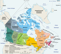
دوتنه:Carte administrative du Canada.png

د همدې ليدنې کچه: ۶۸۰ × ۵۹۹ پېکسل. نورې ژورليدنې: ۲۷۲ × ۲۴۰ پېکسل | ۵۴۵ × ۴۸۰ پېکسل | ۸۷۲ × ۷۶۸ پېکسل | ۱٬۱۶۲ × ۱٬۰۲۴ پېکسل | ۱٬۲۸۰ × ۱٬۱۲۸ پېکسل.
اصلي دوتنه (۱٬۲۸۰ × ۱٬۱۲۸ پېکسل, د دوتنې کچه: ۵۲۲ کيلوبايټ, MIME بڼه: image/png)
د دوتنې پېښليک
په يوې نېټې/يوه وخت وټوکۍ چې د هماغه وخت او نېټې دوتنه چې څنگه ښکارېده هماغسې درښکاره شي.
| نېټه/وخت | بټنوک | ډډې | کارن | تبصره | |
|---|---|---|---|---|---|
| اوسنی | ۲۰:۵۰, ۲۷ اگسټ ۲۰۰۶ |  | ۱٬۲۸۰ × ۱٬۱۲۸ (۵۲۲ کيلوبايټ) | Sting | One more translation; font size for a province |
| ۱۸:۵۸, ۲۷ اگسټ ۲۰۰۶ |  | ۱٬۲۸۰ × ۱٬۱۲۸ (۵۲۳ کيلوبايټ) | Sting | Map translated | |
| ۱۰:۵۹, ۲۷ اگسټ ۲۰۰۶ |  | ۱٬۲۸۰ × ۱٬۱۲۸ (۳۸۴ کيلوبايټ) | Wagner51 | {{Atelier graphique}} <div style="padding:0.5em; width:80%; border:1px solid #5555ff; background-color: #eeeeff"> '''fr :''' Carte administrative du Canada, d'après fr:Image:Map Canada political-geo.png.<br /> Certains noms en anglais effacés par |
د دوتنې کارېدنه
داسې هېڅ کوم مخ نه شته چې د دغې دوتنې سره تړنې ولري.
د نړېوالې دوتنې کارېدنه
همدا دوتنه لاندينۍ نورې ويکي گانې کاروي:
- په ar.wikipedia.org کارونې
- په bg.wikipedia.org کارونې
- په de.wikipedia.org کارونې
- په fa.wikipedia.org کارونې
- په fr.wikipedia.org کارونې
- Utilisateur:Wagner51
- Discussion:Québec (ville)
- Portail:Canada/Section Géographie
- Canada
- Citoyenneté canadienne
- Canadiens francophones
- Portail:Canada/Index thématique
- Liste des villes jumelées du Canada
- Utilisateur:JeanSolPartre/Citoyenneté canadienne
- Projet:Aide et accueil/Twitter/Tweets/archives/janvier 2019
- Wrangellia
- Wikipédia:Atelier graphique/Cartes/Archives/décembre 2020