دوتنه:Weimar Republic 1930.svg

Size of this PNG preview of this SVG file: ۴۵۰ × ۴۵۶ پېکسل. نورې ژورليدنې: ۲۳۷ × ۲۴۰ پېکسل | ۴۷۴ × ۴۸۰ پېکسل | ۷۵۸ × ۷۶۸ پېکسل | ۱٬۰۱۱ × ۱٬۰۲۴ پېکسل | ۲٬۰۲۱ × ۲٬۰۴۸ پېکسل.
اصلي دوتنه (SVG دوتنه، نومېنلي ۴۵۰ × ۴۵۶ پېکسل، د دوتنې کچه: ۴۸۳ کيلوبايټ)
لنډيز


.svg)
.svg)
.svg)
.svg)
.svg)


.svg)
.svg)
.svg)


.png)
.png)


.svg)


.svg)

.svg)


.svg)
.svg)
.svg)
.svg)


.svg)
.png)


.svg)


.svg)
.svg)


.svg)


.svg)


.svg)
.svg)
.svg)
.svg)
.svg)
.svg)
.svg)
_cropped.svg)
.svg)
.svg)
.svg)
.svg)
.svg)
.svg)
.svg)
.svg)
.svg)
.svg)
.svg)
.svg)
.svg)
.svg)
.svg)
.svg)
.svg)
.svg)
.svg)
.svg)
.svg)
.svg)
.svg)
.svg)
.svg)
.svg)
.svg)
.svg)
.svg)
.svg)
.svg)
.svg)
.svg)
.svg)
.svg)
.svg)
.svg)
.svg)
.svg)
.svg)
.svg)
.svg)
.svg)
.svg)
.svg)
منښتليک:
دا دوتنه د کريټيف کامنز Attribution-Share Alike 3.0 Unported په منښتليک سمبال ده.
- تاسې کولی شئ چې:
- بيا يې د نورو سره شريک کړئ – همدا اثر ولمېسئ، و وېشئ او بيا يې خپور کړئ
- بيا ادلون بدلون راولئ – بدل شوی اثر خپل کړئ
- د لاندې شرطونو له مخې:
- اړوندېدنه – تاسې بايد دا اثر د ليکوال يا منښتگر لخوا د ځانگړو شويو اصولو سره اړونده وگڼئ (خو په دې توگه نه چې داسې ښکاره شي چې گنې تاسې يا ستاسې لخوا کارېدنه د اثر د ملاتړ سبب شوی)
- يوشان شريکول – که تاسې همدا اثر بدلوئ، رغوئ، او يا يې هم سر له نوي جوړوئ نو په پايله کې رامېنځ ته شوی اثر به يوازې د همدې دوتنې ورته منښتليک پر بنسټ خپروئ.
Original upload log
This image is a derivative work of the following images:
- File:Blank_map_of_Europe.svg licensed with Cc-by-sa-2.5
- 2011-09-19T22:57:58Z Alphathon 680x520 (603759 Bytes) Added North/Northern Cyprus
- 2011-08-23T10:26:48Z Heb 680x520 (604212 Bytes) Added [[:en:Bornholm]] (taken from [[:File:Denmark blank map.svg]])
- 2011-04-12T00:40:40Z Alphathon 680x520 (602549 Bytes) Upgraded Sicily based on "File:Freeworldmaps-sicily.jpg". Upgraded Malta based on "File:Map of Malta 2.png". Simplified Croatian borders.
- 2011-04-10T21:43:04Z Alphathon 680x520 (607359 Bytes) Upgraded Croatia, Bosnia & Herzegovina, Slovenia and surrounding countries based on data from "File:Kroatien - Politische Gliederung (Karte).png"
- 2011-04-10T20:05:09Z Alphathon 680x520 (568373 Bytes) Improved Serbia, Montenegro and surrounding countries using data from "File:Serbia Map.png". Fixed Serbia-Montenegro border. Added Kosovo (using dashed border, since it is not a universally recognised nation, and left the lan
- 2011-04-10T15:55:02Z Alphathon 680x520 (524980 Bytes) Tweaked Ukraine and surrounding countries based on data from "File:Up-map.png"
- 2011-04-10T04:02:09Z Alphathon 680x520 (511168 Bytes) Improved Greece, Albania, F.Y.R. Macedonia and Bulgaria based on "File:Greece topo.jpg"
- 2011-04-10T02:48:52Z Alphathon 680x520 (505569 Bytes) Tweaked Germany and surrounding countries based on info from "File:Germany_general_map.png"
- 2011-04-10T01:54:05Z Alphathon 680x520 (493733 Bytes) Converted all lakes back to separate layer. Added Finish lakes and tweaked Finland shape based on "File:Finland 1996 CIA map.jpg". Added Swiss lakes based on "File:Suisse cantons.svg". Tweaked Scotland and added Lochs.
- 2011-04-10T00:07:54Z Alphathon 680x520 (450120 Bytes) Improved England outline and added Isle of Wight based on "File:England Regions - Blank.svg". Improved Denmark based on "File:2 digit postcode danmark.png". Improved Sweden based on "File:Map of Sweden, CIA, 1996.jpg"
- 2011-04-08T15:53:07Z Alphathon 680x520 (438878 Bytes) Upgraded/fixed various parts of the map. Details: *Some minor fixes to Ireland and added some of the larger lakes based on [[:File:Ireland_trad_counties_named.svg]] *Pretty major fixes to Scotland (mainly the west coast and i
- 2008-09-17T09:50:25Z F7 680x520 (531491 Bytes) '
- 2008-09-17T09:42:57Z F7 680x520 (2353 Bytes) '
- 2008-05-26T19:04:07Z Collard 680x520 (531491 Bytes) uploading on behalf of [[User:Checkit]], direct complaints to him plox: 'Moved countries out of the "outlines" group, removed "outlines" style class, remove separate style information for Russia'
- 2008-04-30T01:38:52Z TimothyBourke 680x520 (531767 Bytes) Changed the country code of Serbia to RS per [http://en.wikipedia.org/wiki/Serbian_country_codes] and the file [http://www.iso.org/iso/iso3166_en_code_lists.txt].
- 2008-02-08T22:44:37Z CarolSpears 680x520 (531767 Bytes) validated
- 2007-07-10T11:47:59Z MrWeeble 680x520 (533112 Bytes) Updated to include British Crown Dependencies as seperate entities and regroup them as "British Islands", with some simplifications to the XML and CSS
- 2007-05-14T17:17:34Z Zirland 680x520 (540659 Bytes) serbia and montenegro
- 2007-03-30T20:40:49Z W!B: 680x520 (538830 Bytes) minor corr: update nl:Ijsselmeer, del fi:lakes (all small), add ru:lake Oneka (all ref maps.google), glued northern irland back to ie ;)
- 2007-02-05T18:44:32Z Maix 680x520 (538295 Bytes) cropped
- 2007-02-04T15:07:29Z Maix 680x520 (538310 Bytes) {{Information |Description=A blank Map of Europe in SVG format. Every country has an id which is its ISO-3116-1-ALPHA2 code in lower case for easy coloring. |Source=Image based on [[Image:Europe_countries.svg|]] by [[User:Ti
Uploaded with derivativeFX
د دوتنې پېښليک
په يوې نېټې/يوه وخت وټوکۍ چې د هماغه وخت او نېټې دوتنه چې څنگه ښکارېده هماغسې درښکاره شي.
| نېټه/وخت | بټنوک | ډډې | کارن | تبصره | |
|---|---|---|---|---|---|
| اوسنی | ۰۳:۴۷, ۲۴ اپرېل ۲۰۱۸ | | ۴۵۰ × ۴۵۶ (۴۸۳ کيلوبايټ) | TRAJAN 117 | Update |
| ۰۸:۰۰, ۱۲ اگسټ ۲۰۱۳ |  | ۴۵۰ × ۴۵۶ (۴۸۳ کيلوبايټ) | Alphathon | Fixed Yugoslav-Hungarian border (see main file) | |
| ۱۶:۱۲, ۲۵ جولای ۲۰۱۳ |  | ۴۵۰ × ۴۵۶ (۴۶۹ کيلوبايټ) | Alphathon | Removed the Flevoland polders (Netherlands) which were not completed until 1942/1968 | |
| ۰۳:۰۰, ۲۷ اکتوبر ۲۰۱۱ |  | ۴۵۰ × ۴۵۶ (۴۶۹ کيلوبايټ) | Alphathon | Minor tweak | |
| ۰۲:۴۹, ۲۷ اکتوبر ۲۰۱۱ |  | ۴۵۰ × ۴۵۶ (۴۶۹ کيلوبايټ) | Alphathon | Tweaked Romanian borders | |
| ۰۲:۳۰, ۲۷ اکتوبر ۲۰۱۱ |  | ۴۵۰ × ۴۵۶ (۴۶۵ کيلوبايټ) | Alphathon | A few minor fixes (Malta grouped with UK, North Cyprus removed, a few Greek islands moved to Italy per 1930 ownership). | |
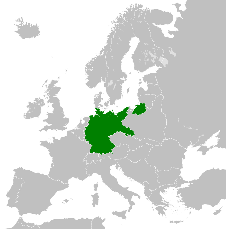
| ۰۲:۱۰, ۲۷ اکتوبر ۲۰۱۱ |  | ۴۵۰ × ۴۵۶ (۴۶۶ کيلوبايټ) | Alphathon | == {{int:filedesc}} == {{Information |Description={{en|A Map of the Weimar Republic within Europe circa 1930.}} |Source=*File:Blank_map_of_Europe.svg |Date=2011-10-27 02:10 (UTC) |Author=*File:Blank_map_of_Europe.svg: maix<sup>[[ |
د دوتنې کارېدنه
دا لاندينی مخ د همدې دوتنې سره تړنې لري:
د نړېوالې دوتنې کارېدنه
همدا دوتنه لاندينۍ نورې ويکي گانې کاروي:
- په af.wikipedia.org کارونې
- په ar.wikipedia.org کارونې
- په arz.wikipedia.org کارونې
- په ast.wikipedia.org کارونې
- په azb.wikipedia.org کارونې
- په az.wikipedia.org کارونې
- په ba.wikipedia.org کارونې
- په bg.wikipedia.org کارونې
- په bxr.wikipedia.org کارونې
- په ca.wikipedia.org کارونې
- په cs.wikipedia.org کارونې
- په el.wikipedia.org کارونې
- په en.wikipedia.org کارونې
- په es.wikipedia.org کارونې
- په fa.wikipedia.org کارونې
- په fi.wikipedia.org کارونې
- په fr.wikipedia.org کارونې
- په ga.wikipedia.org کارونې
- په gd.wikipedia.org کارونې
- په gl.wikipedia.org کارونې
- په gv.wikipedia.org کارونې
- په he.wikipedia.org کارونې
- په hi.wikipedia.org کارونې
- په ia.wikipedia.org کارونې
- په id.wikipedia.org کارونې
- په incubator.wikimedia.org کارونې
- په io.wikipedia.org کارونې
- په it.wikipedia.org کارونې
- په ja.wikipedia.org کارونې
- په kk.wikipedia.org کارونې
- په km.wikipedia.org کارونې
- په ko.wikipedia.org کارونې
- په ky.wikipedia.org کارونې
- په lt.wikipedia.org کارونې
- په mg.wikipedia.org کارونې
- په mn.wikipedia.org کارونې
- په mr.wikipedia.org کارونې
- په ms.wikipedia.org کارونې
- په pap.wikipedia.org کارونې
- په pl.wikipedia.org کارونې
د دې دوتنې نورې نړېوالې کارېدنې کتل.