دوتنه:Pakistan-Waziristan-Map 2.png

د همدې ليدنې کچه: ۶۰۶ × ۵۹۹ پېکسل. نورې ژورليدنې: ۲۴۳ × ۲۴۰ پېکسل | ۴۸۶ × ۴۸۰ پېکسل | ۷۰۰ × ۶۹۲ پېکسل.
اصلي دوتنه (۷۰۰ × ۶۹۲ پېکسل, د دوتنې کچه: ۹۴ کيلوبايټ, MIME بڼه: image/png)
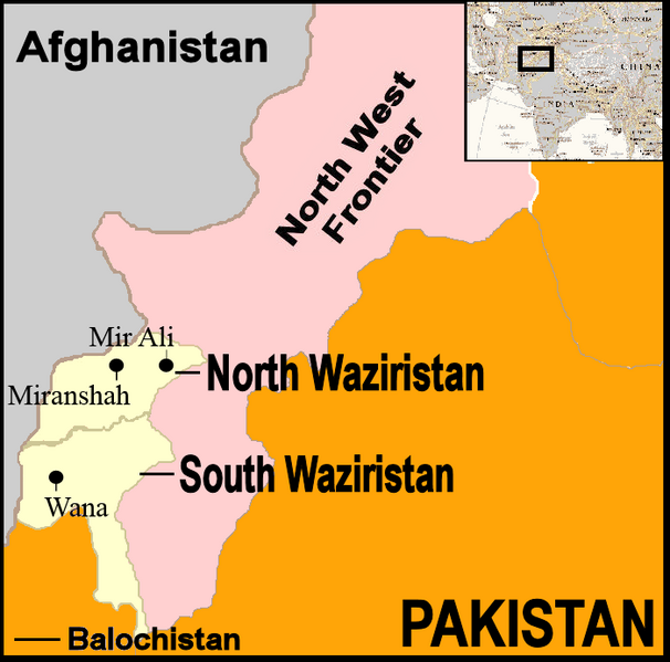
لنډيز
| څرگندونه | Map showing location of North and South Waziristan in northern Pakistan and bordering on Afghanistan |
| نېټه | |
| سرچينه | http://commons.wikimedia.org/wiki/Image:Pakistan-Waziristan-Map.png, PD |
| ليکوال | Thaddeus P. Bejnar and David Orlović |
منښتليک:
| I, the copyright holder of this work, release this work into the public domain. This applies worldwide. In some countries this may not be legally possible; if so: I grant anyone the right to use this work for any purpose, without any conditions, unless such conditions are required by law. |
د دوتنې پېښليک
په يوې نېټې/يوه وخت وټوکۍ چې د هماغه وخت او نېټې دوتنه چې څنگه ښکارېده هماغسې درښکاره شي.
| نېټه/وخت | بټنوک | ډډې | کارن | تبصره | |
|---|---|---|---|---|---|
| اوسنی | ۱۴:۳۷, ۱۰ اکتوبر ۲۰۰۷ | | ۷۰۰ × ۶۹۲ (۹۴ کيلوبايټ) | Orlovic | == Summary == {{Information |Description=Map showing location of North and South Waziristan in northern Pakistan and bordering on Afghanistan |Source=http://commons.wikimedia.org/wiki/Image:Pakistan-Waziristan-Map.png, PD |Date=2007 |Author=Thaddeus P. Be |
د دوتنې کارېدنه
دا لاندينی مخ د همدې دوتنې سره تړنې لري:
د نړېوالې دوتنې کارېدنه
همدا دوتنه لاندينۍ نورې ويکي گانې کاروي:
- په bg.wikipedia.org کارونې
- په de.wikinews.org کارونې
- په en.wikinews.org کارونې
- په pl.wikipedia.org کارونې
- په ru.wikipedia.org کارونې
- په uk.wikipedia.org کارونې
- په www.wikidata.org کارونې