دوتنه:Map Saipan Tinian islands closer.jpg
تر دې کچې لوړې بېلن نښې نشته.
Map_Saipan_Tinian_islands_closer.jpg (۲۹۰ × ۴۱۰ پېکسل, د دوتنې کچه: ۳۱ کيلوبايټ, MIME بڼه: image/jpeg)
لنډيز
| څرگندونه |
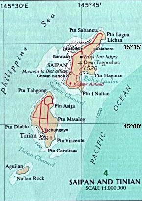
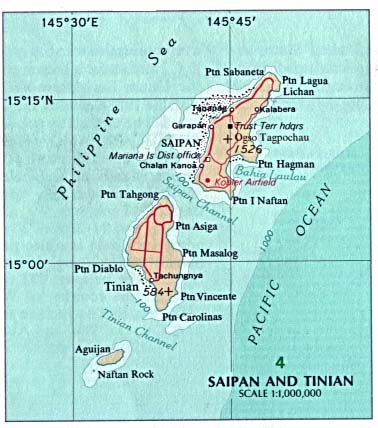
English: Map of the islands of Saipan and Tinian in the Northern Mariana Islands along the Marianas Trench (east of China and the Philippines). |
| نېټه | |
| سرچينه |
Derived by cropping US Government (USNA) map: http://www.lib.utexas.edu/maps/australia/saipan_tinian_islands.jpg linked as being a US National Atlas (1970) map on related webpage: http://www.lib.utexas.edu/maps/northern_mariana_islands.html . |
| ليکوال |
map:US Geological Survey |
| نورې بڼې |
 |
منښتليک:
The map is public domain, derived by User:Wikid77 from a USNA image (in JPEG format).
This image is in the public domain in the United States because it only contains materials that originally came from the United States Geological Survey, an agency of the United States Department of the Interior. For more information, see the official USGS copyright policy.
|
د دوتنې پېښليک
په يوې نېټې/يوه وخت وټوکۍ چې د هماغه وخت او نېټې دوتنه چې څنگه ښکارېده هماغسې درښکاره شي.
| نېټه/وخت | بټنوک | ډډې | کارن | تبصره | |
|---|---|---|---|---|---|
| اوسنی | ۱۴:۳۲, ۷ مارچ ۲۰۰۸ | | ۲۹۰ × ۴۱۰ (۳۱ کيلوبايټ) | Wikid77 | initial upload |
د دوتنې کارېدنه
دا لاندينی مخ د همدې دوتنې سره تړنې لري:
د نړېوالې دوتنې کارېدنه
همدا دوتنه لاندينۍ نورې ويکي گانې کاروي:
- په cs.wikipedia.org کارونې
- په el.wikipedia.org کارونې
- په en.wikipedia.org کارونې
- په eu.wikipedia.org کارونې
- په fa.wikipedia.org کارونې
- په ha.wikipedia.org کارونې
- په hi.wikipedia.org کارونې
- په id.wikipedia.org کارونې
- په it.wikipedia.org کارونې
- په ka.wikipedia.org کارونې
- په ml.wikipedia.org کارونې
- په nl.wikipedia.org کارونې
- په pt.wikipedia.org کارونې
- په sl.wikipedia.org کارونې
- په tr.wikipedia.org کارونې
- په uk.wikipedia.org کارونې
- په vi.wikipedia.org کارونې