دوتنه:Illyrian Tribes (English).svg

Size of this PNG preview of this SVG file: ۶۰۰ × ۶۰۰ پېکسل. نورې ژورليدنې: ۲۴۰ × ۲۴۰ پېکسل | ۴۸۰ × ۴۸۰ پېکسل | ۷۶۸ × ۷۶۸ پېکسل | ۱٬۰۲۴ × ۱٬۰۲۴ پېکسل | ۲٬۰۴۸ × ۲٬۰۴۸ پېکسل | ۱٬۶۰۰ × ۱٬۶۰۰ پېکسل.
اصلي دوتنه (SVG دوتنه، نومېنلي ۱٬۶۰۰ × ۱٬۶۰۰ پېکسل، د دوتنې کچه: ۸٫۵۷ مېگابايټ)
د دوتنې پېښليک
په يوې نېټې/يوه وخت وټوکۍ چې د هماغه وخت او نېټې دوتنه چې څنگه ښکارېده هماغسې درښکاره شي.
| نېټه/وخت | بټنوک | ډډې | کارن | تبصره | |
|---|---|---|---|---|---|
| اوسنی | ۱۶:۵۲, ۲۳ جولای ۲۰۲۲ |  | ۱٬۶۰۰ × ۱٬۶۰۰ (۸٫۵۷ مېگابايټ) | Khirurg | more minor fixes |
| ۱۶:۲۲, ۲۳ جولای ۲۰۲۲ |  | ۱٬۶۰۰ × ۱٬۶۰۰ (۸٫۵۶ مېگابايټ) | Khirurg | More fixes | |
| ۱۵:۰۸, ۲۳ جولای ۲۰۲۲ | 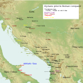 | ۱٬۶۰۰ × ۱٬۶۰۰ (۸٫۵۷ مېگابايټ) | Khirurg | Fixes | |
| ۰۹:۳۴, ۲۵ جون ۲۰۱۶ |  | ۱٬۶۰۰ × ۱٬۶۰۰ (۸٫۵۷ مېگابايټ) | MaryroseB54 | Paionia text position | |
| ۰۰:۱۱, ۲۳ جون ۲۰۱۶ |  | ۱٬۶۰۰ × ۱٬۶۰۰ (۸٫۵۷ مېگابايټ) | MaryroseB54 | The Illyrian Atintani, the Epirotic Atintanes and the Roman Protectorate N. G. L. Hammond, The Journal of Roman Studies Vol. 79 (1989), pp. 11-25 "There were Illyrian Amantini in Pannonia and Greek Amantes in North Epirus" | |
| ۲۱:۴۸, ۲۲ جون ۲۰۱۶ |  | ۱٬۶۰۰ × ۱٬۶۰۰ (۸٫۵۷ مېگابايټ) | MaryroseB54 | position | |
| ۱۹:۴۹, ۲۲ جون ۲۰۱۶ |  | ۱٬۶۰۰ × ۱٬۶۰۰ (۸٫۵۷ مېگابايټ) | MaryroseB54 | Placed Byllis, 25 kilometers from the sea | |
| ۱۴:۰۶, ۲۲ جون ۲۰۱۶ |  | ۱٬۶۰۰ × ۱٬۶۰۰ (۸٫۵۷ مېگابايټ) | MaryroseB54 | 3 Cities in order to make sense of the locations | |
| ۱۰:۱۸, ۱۹ جون ۲۰۱۶ |  | ۱٬۶۰۰ × ۱٬۶۰۰ (۸٫۵۷ مېگابايټ) | MaryroseB54 | Corrected position of 2 tribes | |
| ۱۱:۴۹, ۱۷ جون ۲۰۱۶ |  | ۱٬۶۰۰ × ۱٬۶۰۰ (۸٫۵۷ مېگابايټ) | MaryroseB54 | User created page with UploadWizard |
د دوتنې کارېدنه
داسې هېڅ کوم مخ نه شته چې د دغې دوتنې سره تړنې ولري.
د نړېوالې دوتنې کارېدنه
همدا دوتنه لاندينۍ نورې ويکي گانې کاروي:
- په an.wikipedia.org کارونې
- په ar.wikipedia.org کارونې
- په az.wikipedia.org کارونې
- په be.wikipedia.org کارونې
- په bg.wikipedia.org کارونې
- په bn.wikipedia.org کارونې
- په bs.wikipedia.org کارونې
- په ca.wikipedia.org کارونې
- په cs.wikipedia.org کارونې
- په da.wikipedia.org کارونې
- په en.wikipedia.org کارونې
- په eo.wikipedia.org کارونې
- په fa.wikipedia.org کارونې
- په fy.wikipedia.org کارونې
- په gl.wikipedia.org کارونې
- په he.wikipedia.org کارونې
- په hr.wikipedia.org کارونې
- په hy.wikipedia.org کارونې
- په id.wikipedia.org کارونې
- په it.wikipedia.org کارونې
- په ja.wikipedia.org کارونې
- په ja.wikibooks.org کارونې
- په ka.wikipedia.org کارونې
- په kk.wikipedia.org کارونې
- په ko.wikipedia.org کارونې
- په lt.wikipedia.org کارونې
- په lv.wikipedia.org کارونې
- په mg.wikipedia.org کارونې
- په nl.wikipedia.org کارونې
- په no.wikipedia.org کارونې
- په nrm.wikipedia.org کارونې
د دې دوتنې نورې نړېوالې کارېدنې کتل.


