دوتنه:ID - Timor.PNG

د همدې ليدنې کچه: ۸۰۰ × ۵۴۳ پېکسل. نورې ژورليدنې: ۳۲۰ × ۲۱۷ پېکسل | ۶۴۰ × ۴۳۴ پېکسل | ۸۲۴ × ۵۵۹ پېکسل.
اصلي دوتنه (۸۲۴ × ۵۵۹ پېکسل, د دوتنې کچه: ۲۷ کيلوبايټ, MIME بڼه: image/png)
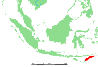
| څرگندونه | ID Tidore.PNG | ||||
| سرچينه | own work based on PD map | ||||
| ليکوال | edited by M.Minderhoud | ||||
| اجازه (دا دوتنه بيا کارول) |
|
د دوتنې پېښليک
په يوې نېټې/يوه وخت وټوکۍ چې د هماغه وخت او نېټې دوتنه چې څنگه ښکارېده هماغسې درښکاره شي.
| نېټه/وخت | بټنوک | ډډې | کارن | تبصره | |
|---|---|---|---|---|---|
| اوسنی | ۱۸:۲۰, ۱۰ اکتوبر ۲۰۰۶ | | ۸۲۴ × ۵۵۹ (۲۷ کيلوبايټ) | Michiel1972 | {{Information |Description= ID Tidore.PNG |Source= own work based on PD map |Date= |Author= edited by M.Minderhoud |Permission= {{PD-Demis}} |other_versions= }} category:Locator maps of islands in Indonesia |
د دوتنې کارېدنه
دا لاندينی مخ د همدې دوتنې سره تړنې لري:
د نړېوالې دوتنې کارېدنه
همدا دوتنه لاندينۍ نورې ويکي گانې کاروي:
- په ar.wikipedia.org کارونې
- په arz.wikipedia.org کارونې
- په ast.wikipedia.org کارونې
- په br.wikipedia.org کارونې
- په ca.wikipedia.org کارونې
- په de.wikipedia.org کارونې
- په de.wiktionary.org کارونې
- په el.wikipedia.org کارونې
- په eo.wikipedia.org کارونې
- په es.wikipedia.org کارونې
- په et.wikipedia.org کارونې
- په eu.wikipedia.org کارونې
- په fi.wiktionary.org کارونې
- په fr.wikipedia.org کارونې
- په fr.wiktionary.org کارونې
- په gl.wikipedia.org کارونې
- په gl.wiktionary.org کارونې
- په ha.wikipedia.org کارونې
- په hr.wikipedia.org کارونې
- په ie.wikipedia.org کارونې
- په it.wikipedia.org کارونې
- په ja.wikipedia.org کارونې
- په ko.wikipedia.org کارونې
- په lb.wikipedia.org کارونې
- په nl.wikipedia.org کارونې
- په nn.wikipedia.org کارونې
- په pt.wikipedia.org کارونې
- په sh.wikipedia.org کارونې
- په sl.wikipedia.org کارونې
- په sr.wikipedia.org کارونې
- په stq.wikipedia.org کارونې
- په uk.wikipedia.org کارونې
- په ur.wikipedia.org کارونې
- په vi.wikipedia.org کارونې
- په www.wikidata.org کارونې