دوتنه:Eritrean Railway - 2008-11-04-edit1.jpg

د همدې ليدنې کچه: ۸۰۰ × ۶۰۰ پېکسل. نورې ژورليدنې: ۳۲۰ × ۲۴۰ پېکسل | ۶۴۰ × ۴۸۰ پېکسل | ۱٬۰۲۴ × ۷۶۸ پېکسل | ۱٬۲۸۰ × ۹۶۰ پېکسل | ۲٬۴۰۰ × ۱٬۸۰۰ پېکسل.
اصلي دوتنه (۲٬۴۰۰ × ۱٬۸۰۰ پېکسل, د دوتنې کچه: ۱٫۸۶ مېگابايټ, MIME بڼه: image/jpeg)
لنډيز
| Photographer |
Original photograph taken by User:Voice of Clam, edited by jjron - adjusted levels, reduced highlights, sharpened. |
| څرگندونه |
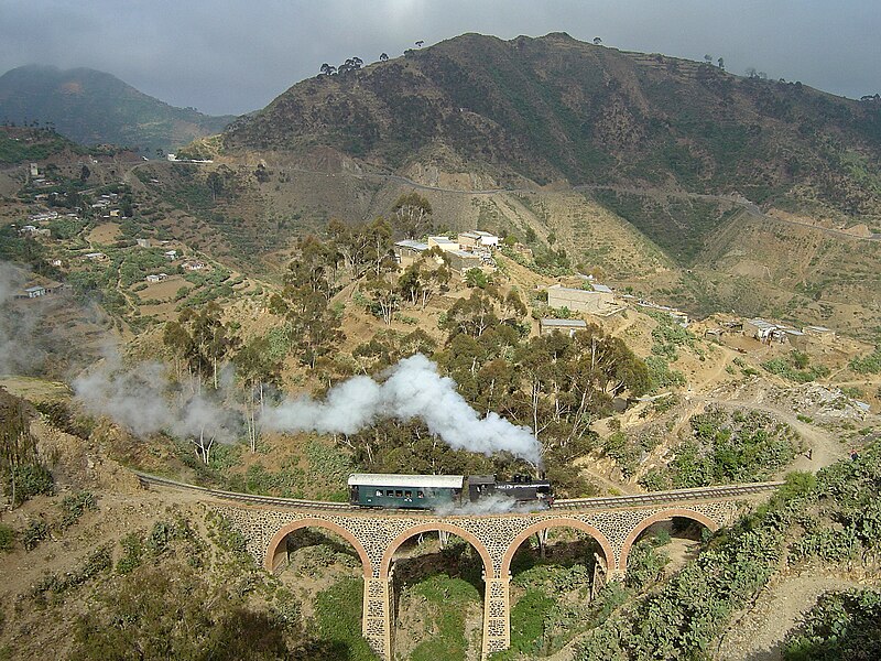
English: Eritrean Railway, showing mountainous terrain traversed between Arbaroba and Asmara.
Български: Еритрейската ЖП линия е посроена през италианското колониално време
Deutsch: Eisenbahn in Eritrea
Esperanto: Fervojoj en Eritreo
Español: Ferrocarril en Eritrea construido por los italianos
Français : Sur les chemins de fer érythréens, actuellement seulement exploités entre Massaoua et Asmara, une locomotive de la série 440 circule sur la section montagneuse entre Arbaroba et Asmara, au niveau de la « porte du Diable »
עברית: רכבת חוצה גשר באריתראה
Bahasa Indonesia: Jalur kereta api Eritrea, yang kini hanya menghubungkan Massawa dan Asmara
Italiano: Una locomotiva della Ferrovia Eritrea mentre attraversa gli altopiani
日本語: 山岳部を走るイタリア領時代に建設されたエリトリア鉄道
Ladino: Tréno en Eritrea de orijin italiano
Polski: Kolej Massaua - Asmara: Lokomotywa klasy 440 na odcinku Arbaroba - Asmara
پښتو: اریتره
Português: A Ferrovia da Eritreia foi construída durante o colonialismo italiano |
| نېټه | Taken on ۴ نومبر ۲۰۰۸ |
| سرچينه | This file was derived from: Eritrean Railway - 2008-11-04.jpg by Voice of Clam |
| اجازه (دا دوتنه بيا کارول) |
See below |
| نورې بڼې |
|
| Camera | Sony DSC-P12 |
| Notes |
|
| اړيکه | I can be contacted: |
| See also |
|


| Camera location | | View this and other nearby images on: OpenStreetMap |
|---|
منښتليک:
| This work has been released into the public domain by its author, Voice of Clam. This applies worldwide. In some countries this may not be legally possible; if so: Voice of Clam grants anyone the right to use this work for any purpose, without any conditions, unless such conditions are required by law. |
Assessments
|
derivative works
Derivative works of this file: Eritrean Railway banner.jpg
د دوتنې پېښليک
په يوې نېټې/يوه وخت وټوکۍ چې د هماغه وخت او نېټې دوتنه چې څنگه ښکارېده هماغسې درښکاره شي.
| نېټه/وخت | بټنوک | ډډې | کارن | تبصره | |
|---|---|---|---|---|---|
| اوسنی | ۱۸:۵۵, ۸ نومبر ۲۰۰۹ | | ۲٬۴۰۰ × ۱٬۸۰۰ (۱٫۸۶ مېگابايټ) | Voice of Clam | As this version is a Featured Image on enwiki, I do not think it is appropriate to replace it without discussion. I will upload the new version with a different name. |
| ۰۵:۴۲, ۸ نومبر ۲۰۰۹ |  | ۲٬۴۰۰ × ۱٬۸۰۰ (۱٫۸۷ مېگابايټ) | Citypeek | white balance | |
| ۱۲:۳۸, ۱۴ نومبر ۲۰۰۸ |  | ۲٬۴۰۰ × ۱٬۸۰۰ (۱٫۸۶ مېگابايټ) | Jjron | {{User:Tivedshambo/Information |Description={{w|Eritrean Railway}}, showing mountainous terrain traversed between Arbaroba and {{w|Asmara}}. <br>This is an edited version of Image:Eritrean Railway - Tivedshambo 2008-11-04.jpg by jjron |
د دوتنې کارېدنه
دا لاندينی مخ د همدې دوتنې سره تړنې لري:
د نړېوالې دوتنې کارېدنه
همدا دوتنه لاندينۍ نورې ويکي گانې کاروي:
- په bg.wikipedia.org کارونې
- په bs.wikipedia.org کارونې
- په cy.wikipedia.org کارونې
- په de.wikipedia.org کارونې
- په en.wikipedia.org کارونې
- Eritrean Railway
- 1911 in rail transport
- Portal:Africa/Featured picture
- Wikipedia:Featured pictures thumbs/14
- Wikipedia:Picture peer review/Archives/Oct-Dec 2008
- Wikipedia:Picture peer review/Eritrean Railway
- Wikipedia:Featured picture candidates/Eritrean Railway
- Wikipedia:Wikipedia Signpost/2009-01-03/Features and admins
- Wikipedia:Featured picture candidates/December-2008
- Portal:Africa/Featured picture/29
- Wikipedia:Picture of the day/September 2009
- Template:POTD/2009-09-15
- User talk:Sarah777/Archive 25
- Portal:Eritrea/Featured picture
- Portal:Eritrea/Featured article
- Portal:Eritrea
- Portal:Eritrea/Featured picture/8
- Wikipedia:Featured pictures/Vehicles/Land
- Wikipedia:Wikipedia Signpost/2010-09-20/WikiProject report
- User talk:Voice of Clam/Archives/2008
- User talk:Voice of Clam/Archives/2009
- List of companies based in Eritrea
- Portal:Trains/Selected article/2014 archive
- Portal:Trains/Selected article/Week 34, 2014
- Wikipedia:Wikipedia Signpost/2009-01-03/SPV
- Wikipedia:Wikipedia Signpost/Single/2010-09-20
- User talk:Voice of Clam/Archives
- Portal:Trains/Did you know/December 2016
- User:Alb2017/sandbox
- Italian colonial railways
- Portal:Eritrea/Featured article/7
- User:Moonraker/P
- Wikipedia:Wikipedia Signpost/Single/2009-01-03
- په eo.wikipedia.org کارونې
- په es.wikipedia.org کارونې
- په fa.wikipedia.org کارونې
- په fr.wikipedia.org کارونې
- په ha.wikipedia.org کارونې
د دې دوتنې نورې نړېوالې کارېدنې کتل.