دوتنه:Crazywell cross 1.JPG

د همدې ليدنې کچه: ۸۰۰ × ۶۰۰ پېکسل. نورې ژورليدنې: ۳۲۰ × ۲۴۰ پېکسل | ۶۴۰ × ۴۸۰ پېکسل | ۱٬۰۲۴ × ۷۶۸ پېکسل | ۱٬۲۸۰ × ۹۶۰ پېکسل | ۲٬۰۴۸ × ۱٬۵۳۶ پېکسل.
اصلي دوتنه (۲٬۰۴۸ × ۱٬۵۳۶ پېکسل, د دوتنې کچه: ۱٫۴۲ مېگابايټ, MIME بڼه: image/jpeg)
|

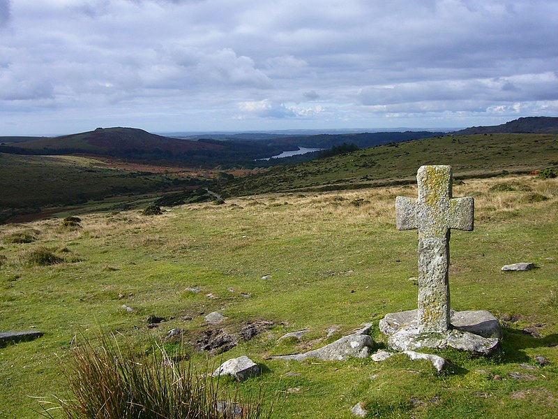
This image was selected as picture of the day on Wikimedia Commons for 8 June 2009. It was captioned as follows: English: Ancient cross close to Crazywell Pool on southern Dartmoor. Other languages:
Bahasa Indonesia: Salib tua di dekat kolam Crazywell di Dartmoor selatan, Inggris. Dansk: Gammelt kors nær Crazywell Pool i den sydlige del af Dartmoor nationalpark i Storbritannien. Deutsch: Steinkreuz im Dartmoor, Südwestengland English: Ancient cross close to Crazywell Pool on southern Dartmoor. Español: Cruz antigua cerca de Crazywell Pool, al sur de Dartmoor. Esperanto: antikva ŝtona kruco proksime al la lageto Crazywell Pool en la nacia parko Dartmoor en Britio Français : Ancienne croix près de l'étang de Crazywell, dans le sud du parc naturel du Dartmoor. Elle était vraisemblablement utilisée comme marque de balisage pour le chemin allant du monastère de Buckfast au monastère de Tavistock. Nederlands: oud kruis nabij de Crazywell Pool in het zuiden van de Dartmoor in het Engelse graafschap Devon Polski: Starodawny krzyż w pobliżu Crazywell Pool, na południe od Parku Narodowego Dartmoor Română: Cruce veche, lângă Crazywell Pool, în sudul Dartmoorului. Македонски: Древен крст близу Крејзивел Пул во јужен Дартмур. 한국어: 남부 다트무어 Crazywell Pool 가까운 곳에 위치한 고대 십자가 中文: 达特穆尔南部疯狂井池古老的十字架。 中文(繁體): 達特穆爾南部瘋狂井池古老的十字架。 |

|
This image has been assessed under the valued image criteria and is considered the most valued image on Commons within the scope: Dartmoor Crosses. You can see its nomination here. |
لنډيز
| څرگندونه |
English: Ancient cross close to Crazywell Pool on southern Dartmoor. It may well have been used as a marker for the track from the monastery at Buckfast to the monastery at Tavistock. Burrator reservoir can be seen in the distance.
Français : Ancienne croix près de l'étang de Crazywell, dans le sud du parc naturel du Dartmoor. Elle était vraisemblablement utilisée comme marque de balisage pour le chemin allant du monastère de Buckfast au monastère de Tavistock. Le lac réservoir de Burrator est visible à l'arrière-plan
Deutsch: Historisches Kreuz in der Nähe von Crazywell Pool im südlichen Dartmoor (Devon, UK). Möglicherweise wurde es als Wegweiser vom Kloster in Buckfast zum Kloster von Tavistock genutzt. Im Hintergrund ist das Wasserreservoir von Burrator zu erkennen. |
| نېټه | ۲۹ سپټمبر ۲۰۰۸ (created) |
| سرچينه | شخصي اثر |
| ليکوال | Myself – Herby talk thyme |
| Camera location | | View this and other nearby images on: OpenStreetMap |
|---|
منښتليک:
I, the copyright holder of this work, hereby publish it under the following licenses:

|
د دې لاسوند د لمېسلو، وېشلو او/يا هم د بدلولو پرېښه د GNU د وړيا لاسوندکښنې منښتليک 1.2 بڼې او يا هم تر دې نوې بڼې چې د وړيا ساوتريو بنسټ لخوا خپره شوې وي ورکړل شوې، د نابدلېدونکو برخو او د مخ-پوښ او د شا-پوښ د متنونو پرته. د دې منښتليک يوه لمېسه د GNU د وړيا لاسوندکښنې منښتليک په سرليک برخه کې شامل شوی. |
This file is licensed under the Creative Commons Attribution-Share Alike 4.0 International, 3.0 Unported, 2.5 Generic, 2.0 Generic and 1.0 Generic license.
- تاسې کولی شئ چې:
- بيا يې د نورو سره شريک کړئ – همدا اثر ولمېسئ، و وېشئ او بيا يې خپور کړئ
- بيا ادلون بدلون راولئ – بدل شوی اثر خپل کړئ
- د لاندې شرطونو له مخې:
- اړوندېدنه – تاسې بايد دا اثر د ليکوال يا منښتگر لخوا د ځانگړو شويو اصولو سره اړونده وگڼئ (خو په دې توگه نه چې داسې ښکاره شي چې گنې تاسې يا ستاسې لخوا کارېدنه د اثر د ملاتړ سبب شوی)
- يوشان شريکول – که تاسې همدا اثر بدلوئ، رغوئ، او يا يې هم سر له نوي جوړوئ نو په پايله کې رامېنځ ته شوی اثر به يوازې د همدې دوتنې ورته منښتليک پر بنسټ خپروئ.
تاسې د خپلې خوښې منښتليک ټاکلی شی.
د دوتنې پېښليک
په يوې نېټې/يوه وخت وټوکۍ چې د هماغه وخت او نېټې دوتنه چې څنگه ښکارېده هماغسې درښکاره شي.
| نېټه/وخت | بټنوک | ډډې | کارن | تبصره | |
|---|---|---|---|---|---|
| اوسنی | ۱۰:۰۵, ۱ اکتوبر ۲۰۰۸ | | ۲٬۰۴۸ × ۱٬۵۳۶ (۱٫۴۲ مېگابايټ) | Herbythyme | {{Information| |Description = Ancient cross close to Crazywell Pool on southern Dartmoor. It may well have been used as a marker for the track from the monastery at Buckfast to the monastery at Tavistock. |Source = self-made |Date = c |
د دوتنې کارېدنه
دا لاندينی مخ د همدې دوتنې سره تړنې لري:
د نړېوالې دوتنې کارېدنه
همدا دوتنه لاندينۍ نورې ويکي گانې کاروي:
- په bg.wikipedia.org کارونې
- په bn.wikipedia.org کارونې
- په crh.wikipedia.org کارونې
- په cv.wikipedia.org کارونې
- په en.wikipedia.org کارونې
- Dartmoor
- South West England
- Crazywell Pool
- Wikipedia:WikiProject UK geography
- Wikipedia:Featured pictures/Places/Landscapes
- Wikipedia:Featured pictures thumbs/15
- User talk:Herbythyme/Arc4
- Wikipedia:Featured picture candidates/Crazywell Cross
- Dartmoor crosses
- Wikipedia:Featured picture candidates/February-2009
- Wikipedia:Wikipedia Signpost/2009-02-08/Features and admins
- Portal:England/Selected picture/04 2009
- User talk:Herbythyme/Arc5
- Wikipedia:Picture of the day/November 2009
- Template:POTD/2009-11-15
- Wikipedia:Did you know/Statistics/Monthly DYK pageview leaders/2009
- Wikipedia:Recent additions/2009/February
- User talk:Mbz1/Archive1
- Wikipedia:WikiProject Devon/Featured content
- Wikipedia:Wikipedia Signpost/2009-02-08/SPV
- Wikipedia:WikiProject England/The West Country Challenge
- Wikipedia:WikiProject England/The West Country Challenge/Devon
- User:Trans-Neptunian object
- Wikipedia:Wikipedia Signpost/Single/2009-02-08
- په fi.wikipedia.org کارونې
- په fr.wikipedia.org کارونې
- په he.wikipedia.org کارونې
- په hu.wikipedia.org کارونې
- په it.wikipedia.org کارونې
- په ko.wikipedia.org کارونې
- په lbe.wikipedia.org کارونې
- په lt.wikipedia.org کارونې
- په lv.wikipedia.org کارونې
- په mk.wikipedia.org کارونې
- په ml.wikipedia.org کارونې
- په nl.wikipedia.org کارونې
- په os.wikipedia.org کارونې
- په pl.wikipedia.org کارونې
د دې دوتنې نورې نړېوالې کارېدنې کتل.