دوتنه:Cn-map.png
تر دې کچې لوړې بېلن نښې نشته.
Cn-map.png (۳۳۰ × ۳۵۵ پېکسل, د دوتنې کچه: ۶ کيلوبايټ, MIME بڼه: image/png)

|
This locator map image could be re-created using vector graphics as an SVG file. This has several advantages; see Commons:Media for cleanup for more information. If an SVG form of this image is available, please upload it and afterwards replace this template with
{{vector version available|new image name}}.
It is recommended to name the SVG file “Cn-map.svg”—then the template Vector version available (or Vva) does not need the new image name parameter. |
لنډيز
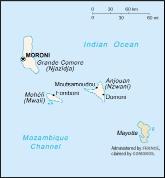
CIA map of the Comoros
منښتليک:
This image is in the public domain because it contains materials that originally came from the United States Central Intelligence Agency's World Factbook.
|
 |
derivative works
Derivative works of this file:
د دوتنې پېښليک
په يوې نېټې/يوه وخت وټوکۍ چې د هماغه وخت او نېټې دوتنه چې څنگه ښکارېده هماغسې درښکاره شي.
| نېټه/وخت | بټنوک | ډډې | کارن | تبصره | |
|---|---|---|---|---|---|
| اوسنی | ۲۰:۱۳, ۲۸ فبروري ۲۰۰۵ | | ۳۳۰ × ۳۵۵ (۶ کيلوبايټ) | Alfio | CIA map of Comoros |
د دوتنې کارېدنه
دا لاندينی مخ د همدې دوتنې سره تړنې لري:
د نړېوالې دوتنې کارېدنه
همدا دوتنه لاندينۍ نورې ويکي گانې کاروي:
- په ab.wikipedia.org کارونې
- په als.wikipedia.org کارونې
- په ar.wikipedia.org کارونې
- په ast.wikipedia.org کارونې
- په be-tarask.wikipedia.org کارونې
- په be.wikipedia.org کارونې
- په bjn.wikipedia.org کارونې
- په bn.wikipedia.org کارونې
- په bs.wikipedia.org کارونې
- په ceb.wikipedia.org کارونې
- په cy.wikipedia.org کارونې
- په da.wikipedia.org کارونې
- په de.wikinews.org کارونې
- په el.wikipedia.org کارونې
- په en.wikipedia.org کارونې
- په es.wikipedia.org کارونې
- په eu.wikipedia.org کارونې
- په fa.wikipedia.org کارونې
- په fi.wikipedia.org کارونې
- په frr.wikipedia.org کارونې
- په fr.wikipedia.org کارونې
- په fr.wikinews.org کارونې
- په gd.wikipedia.org کارونې
- په gl.wikipedia.org کارونې
- په he.wikipedia.org کارونې
- په hi.wikipedia.org کارونې
- په hi.wiktionary.org کارونې
- په hu.wikipedia.org کارونې
- په hu.wiktionary.org کارونې
- په id.wikipedia.org کارونې
د دې دوتنې نورې نړېوالې کارېدنې کتل.