دوتنه:Be-map.png

تر دې کچې لوړې بېلن نښې نشته.
Be-map.png (۵۵۹ × ۶۰۰ پېکسل, د دوتنې کچه: ۱۷۶ کيلوبايټ, MIME بڼه: image/png)

|
This locator map image could be re-created using vector graphics as an SVG file. This has several advantages; see Commons:Media for cleanup for more information. If an SVG form of this image is available, please upload it and afterwards replace this template with
{{vector version available|new image name}}.
It is recommended to name the SVG file “Be-map.svg”—then the template Vector version available (or Vva) does not need the new image name parameter. |
لنډيز
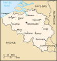
| څرگندونه | Belgium map from CIA World Factbook (since ۸ مې ۲۰۰۶), converted from original GIF format |
| نېټه | |
| سرچينه |
CIA World Factbook |
| ليکوال | United States Central Intelligence Agency |
| نورې بڼې |
|
.png)
منښتليک:
This image is in the public domain because it contains materials that originally came from the United States Central Intelligence Agency's World Factbook.
|
 |
Derivative works
Derivatives of 2006 map:


Derivatives of 2004 map:


Derivatives of 2000 map:
-
 Belgie-mapa.PNG
čeština -
 Be-map-eo.png
Esperanto -
 Be-map-es.png
español -
 Be-map-fr.png
français -
 Be-map-nl.png
Nederlands -
 Belgium-map-nl.png
Nederlands -
 Belgium üres.png
 -
 Ath in Belgium.png
 -
 Dendermonde location map.png
 -
 Vlaamse ruit.png


د دوتنې پېښليک
په يوې نېټې/يوه وخت وټوکۍ چې د هماغه وخت او نېټې دوتنه چې څنگه ښکارېده هماغسې درښکاره شي.
| نېټه/وخت | بټنوک | ډډې | کارن | تبصره | |
|---|---|---|---|---|---|
| اوسنی | ۲۱:۴۸, ۱۳ اپرېل ۲۰۲۰ | | ۵۵۹ × ۶۰۰ (۱۷۶ کيلوبايټ) | Le Fou | Zeebrugge is not a city, but part of the city of Bruges. |
| ۱۹:۱۳, ۲۱ جولای ۲۰۱۸ |  | ۱٬۰۲۴ × ۱٬۰۹۹ (۲۴ کيلوبايټ) | Karel Adriaan | Resized to 1024 | |
| ۲۰:۴۸, ۲۰ اپرېل ۲۰۰۷ |  | ۳۲۸ × ۳۵۳ (۱۲ کيلوبايټ) | Tene~commonswiki | Optimised (0) | |
| ۱۷:۰۷, ۱۱ مارچ ۲۰۰۷ |  | ۳۲۸ × ۳۵۳ (۱۳ کيلوبايټ) | Feydey | 2007 factbook map | |
| ۱۳:۵۵, ۲۷ مې ۲۰۰۶ |  | ۳۲۹ × ۳۵۳ (۲۰ کيلوبايټ) | Matt314 | "Redu" in the same font size as the other cities | |
| ۲۰:۵۹, ۷ اپرېل ۲۰۰۶ |  | ۳۲۹ × ۳۵۳ (۲۰ کيلوبايټ) | Abrev | Map of Belgium Updated version uploaded by [http://de.wikipedia.org/wiki/Benutzer:Tzzzpfff]. No rights reserved for updating. | |
| ۱۶:۴۶, ۵ جنوري ۲۰۰۶ |  | ۳۳۰ × ۳۵۵ (۹ کيلوبايټ) | Jrenier | Reverted to earlier revision | |
| ۱۶:۳۵, ۵ جنوري ۲۰۰۶ |  | ۳۳۰ × ۳۵۵ (۹ کيلوبايټ) | Jrenier | Reverted to earlier revision | |
| ۱۹:۵۳, ۳ جنوري ۲۰۰۶ |  | ۳۳۰ × ۳۵۵ (۲۸ کيلوبايټ) | Iunity | ||
| ۱۹:۲۴, ۲۷ نومبر ۲۰۰۴ |  | ۳۳۰ × ۳۵۵ (۹ کيلوبايټ) | Kneiphof | Map of Belgium, CIA factbook (taken from EN Wikipedia) |
د دوتنې کارېدنه
دا لاندينی مخ د همدې دوتنې سره تړنې لري:
د نړېوالې دوتنې کارېدنه
همدا دوتنه لاندينۍ نورې ويکي گانې کاروي:
- په als.wikipedia.org کارونې
- په ay.wikipedia.org کارونې
- په azb.wikipedia.org کارونې
- په az.wikipedia.org کارونې
- په bcl.wikipedia.org کارونې
- په be-tarask.wikipedia.org کارونې
- په bg.wiktionary.org کارونې
- په bn.wikipedia.org کارونې
- په bs.wikipedia.org کارونې
- په ca.wikipedia.org کارونې
- په de.wikipedia.org کارونې
- په de.wikinews.org کارونې
- په dsb.wikipedia.org کارونې
- په en.wikipedia.org کارونې
- په en.wikinews.org کارونې
- په en.wikivoyage.org کارونې
- په en.wiktionary.org کارونې
- په es.wikipedia.org کارونې
- په fa.wikipedia.org کارونې
- په fi.wikipedia.org کارونې
- په fr.wikipedia.org کارونې
- په fr.wikinews.org کارونې
- په gag.wikipedia.org کارونې
- په ga.wikipedia.org کارونې
- په gl.wikipedia.org کارونې
- په ha.wikipedia.org کارونې
- په hi.wikipedia.org کارونې
- په hy.wikipedia.org کارونې
- په incubator.wikimedia.org کارونې
- په io.wikipedia.org کارونې
د دې دوتنې نورې نړېوالې کارېدنې کتل.