دوتنه:Bangladesh divisions english.svg

Size of this PNG preview of this SVG file: ۴۳۲ × ۵۹۹ پېکسل. نورې ژورليدنې: ۱۷۳ × ۲۴۰ پېکسل | ۳۴۶ × ۴۸۰ پېکسل | ۵۵۴ × ۷۶۸ پېکسل | ۷۳۸ × ۱٬۰۲۴ پېکسل | ۱٬۴۷۶ × ۲٬۰۴۸ پېکسل | ۱٬۵۵۰ × ۲٬۱۵۰ پېکسل.
اصلي دوتنه (SVG دوتنه، نومېنلي ۱٬۵۵۰ × ۲٬۱۵۰ پېکسل، د دوتنې کچه: ۱۱۷ کيلوبايټ)
لنډيز
| څرگندونه |
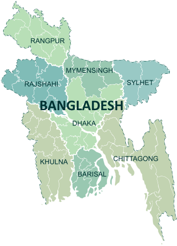
English: Administrative Division of Bangladesh. Colored and vivid. Refined Outlines. Editable SVG. Intended to replace File:Bangladesh divisions english.png
Nafsadh 12:21, 29 March 2011 (UTC) বাংলা: বাংলাদেশের প্রশাসনিক বিভাগ। |
||
| نېټه | |||
| سرچينه | شخصي اثر | ||
| ليکوال | Nafsadh | ||
| نورې بڼې |
|
||
| SVG genesis |

منښتليک:
I, the copyright holder of this work, hereby publish it under the following licenses:
| I, the copyright holder of this work, release this work into the public domain. This applies worldwide. In some countries this may not be legally possible; if so: I grant anyone the right to use this work for any purpose, without any conditions, unless such conditions are required by law. |
| This file is made available under the Creative Commons CC0 1.0 Universal Public Domain Dedication. | |
| The person who associated a work with this deed has dedicated the work to the public domain by waiving all of their rights to the work worldwide under copyright law, including all related and neighboring rights, to the extent allowed by law. You can copy, modify, distribute and perform the work, even for commercial purposes, all without asking permission.
|
تاسې د خپلې خوښې منښتليک ټاکلی شی.
د دوتنې پېښليک
په يوې نېټې/يوه وخت وټوکۍ چې د هماغه وخت او نېټې دوتنه چې څنگه ښکارېده هماغسې درښکاره شي.
| نېټه/وخت | بټنوک | ډډې | کارن | تبصره | |
|---|---|---|---|---|---|
| اوسنی | ۱۳:۴۷, ۶ اپرېل ۲۰۱۸ | | ۱٬۵۵۰ × ۲٬۱۵۰ (۱۱۷ کيلوبايټ) | Nafsadh | Reverted to version as of 14:59, 1 October 2015 (UTC) pending https://en.wikipedia.org/wiki/Wikipedia_talk:WikiProject_Bangladesh#Placename_changes_and_Wikipedia_policy |
| ۲۱:۲۴, ۴ اپرېل ۲۰۱۸ |  | ۱٬۵۵۰ × ۲٬۱۵۰ (۱۲۶ کيلوبايټ) | আফতাবুজ্জামান | বানান হালনাগাদ | |
| ۱۴:۵۹, ۱ اکتوبر ۲۰۱۵ |  | ۱٬۵۵۰ × ۲٬۱۵۰ (۱۱۷ کيلوبايټ) | Nafsadh | Alt proposal of Mymensingh division was adopted. Updated accordingly | |
| ۱۶:۱۰, ۱۶ جنوري ۲۰۱۵ |  | ۱٬۰۵۰ × ۱٬۴۵۰ (۳۱۵ کيلوبايټ) | Nafsadh | Mymensingh division is yet to be enacted | |
| ۱۳:۱۴, ۱۵ جنوري ۲۰۱۵ |  | ۱٬۵۵۰ × ۲٬۱۵۰ (۱۱۸ کيلوبايټ) | Nafsadh | texts as outline | |
| ۱۳:۱۰, ۱۵ جنوري ۲۰۱۵ |  | ۱٬۵۵۰ × ۲٬۱۵۰ (۹۷ کيلوبايټ) | Nafsadh | With newly created division of Mymensingh | |
| ۲۱:۵۷, ۲۴ اکتوبر ۲۰۱۴ |  | ۱٬۰۵۰ × ۱٬۴۵۰ (۳۱۵ کيلوبايټ) | Nafsadh | removed raster | |
| ۰۳:۱۰, ۲۴ اکتوبر ۲۰۱۴ |  | ۱٬۰۵۰ × ۱٬۴۵۰ (۴۹۳ کيلوبايټ) | Nafsadh | lighter | |
| ۰۳:۰۵, ۲۴ اکتوبر ۲۰۱۴ |  | ۱٬۰۵۰ × ۱٬۴۵۰ (۴۹۳ کيلوبايټ) | Nafsadh | opacity | |
| ۰۲:۵۶, ۲۴ اکتوبر ۲۰۱۴ |  | ۱٬۰۵۰ × ۱٬۴۵۰ (۴۹۳ کيلوبايټ) | Nafsadh | green |
د دوتنې کارېدنه
دا 10 لانديني مخونه د همدې دوتنې سره تړنې لري:
د نړېوالې دوتنې کارېدنه
همدا دوتنه لاندينۍ نورې ويکي گانې کاروي:
- په ami.wikipedia.org کارونې
- په be-tarask.wikipedia.org کارونې
- په be.wikipedia.org کارونې
- په bg.wikipedia.org کارونې
- په bs.wikipedia.org کارونې
- په ca.wikipedia.org کارونې
- په cs.wikipedia.org کارونې
- په cy.wikipedia.org کارونې
- په da.wikipedia.org کارونې
- په de.wikipedia.org کارونې
- په en.wikipedia.org کارونې
- Bangladesh
- Divisions of Bangladesh
- Barisal Division
- Feni District
- Chittagong Division
- Dhaka Division
- Cox's Bazar District
- Sylhet Division
- Rajshahi Division
- Comilla District
- Jamalpur District
- Pabna District
- Jessore District
- Tangail District
- Noakhali District
- Gopalganj District, Bangladesh
- Natore District
- Barisal District
- Kushtia District
- Sunamganj District
- Kurigram District
- Bhola District
- Chandpur District
- Manikganj District
- Narayanganj District
- Mymensingh District
- Magura District
- Rangamati Hill District
- Chuadanga District
- Bandarban District
- Brahmanbaria District
- Khagrachhari District
- Lakshmipur District
- Faridpur District
- Rajshahi District
- Template:Divisions and districts of Bangladesh
- Dinajpur District, Bangladesh
د دې دوتنې نورې نړېوالې کارېدنې کتل.