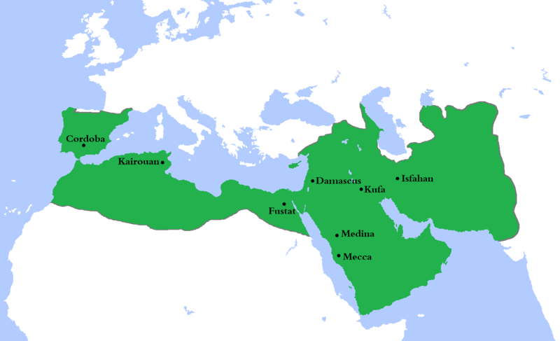
دوتنه:Umayyad750ADloc.png

د همدې ليدنې کچه: ۸۰۰ × ۴۸۷ پېکسل. نورې ژورليدنې: ۳۲۰ × ۱۹۵ پېکسل | ۶۴۰ × ۳۹۰ پېکسل | ۱٬۰۲۴ × ۶۲۴ پېکسل | ۱٬۴۸۱ × ۹۰۲ پېکسل.
اصلي دوتنه (۱٬۴۸۱ × ۹۰۲ پېکسل, د دوتنې کچه: ۴۴ کيلوبايټ, MIME بڼه: image/png)
د دوتنې پېښليک
په يوې نېټې/يوه وخت وټوکۍ چې د هماغه وخت او نېټې دوتنه چې څنگه ښکارېده هماغسې درښکاره شي.
| نېټه/وخت | بټنوک | ډډې | کارن | تبصره | |
|---|---|---|---|---|---|
| اوسنی | ۲۲:۲۳, ۴ اگسټ ۲۰۲۰ |  | ۱٬۴۸۱ × ۹۰۲ (۴۴ کيلوبايټ) | Ozan33Ankara | Corrected borders based on: The expansion of the Muslim Caliphate until 750, from William R. Shepherd's Historical Atlas. |
| ۱۵:۲۴, ۱۱ اپرېل ۲۰۱۳ |  | ۱٬۴۸۱ × ۹۰۲ (۳۰ کيلوبايټ) | HistoryofIran | {{subst:Upload marker added by en.wp UW}} {{Information |Description = {{en|Made the map more presice, the Umayyads never controlled Tabaristan because of the Dabuyid dynasty, but the Abbasids did that later.}} |Source = http://en.wikipedia.org/wiki/Fi... | |
| ۱۵:۵۵, ۱۰ اپرېل ۲۰۱۳ |  | ۱٬۴۸۱ × ۹۰۲ (۳۷ کيلوبايټ) | Khateeb88 | Added the major cities of the Umayyad Caliphate: Damascus, Kufa, Isfahan, Mecca, Medina, Fustat, Kairouan, and Cordoba. | |
| ۱۵:۵۴, ۱۰ اپرېل ۲۰۱۳ |  | ۱٬۴۸۱ × ۹۰۲ (۳۷ کيلوبايټ) | Khateeb88 | Added the major cities of the Umayyad Caliphate: Damascus, Kufa, Isfahan, Mecca, Medina, Fustat, Kairouan, and Cordoba. | |
| ۱۶:۱۷, ۲۲ اپرېل ۲۰۰۹ |  | ۱٬۴۸۱ × ۹۰۲ (۵۰ کيلوبايټ) | Gabagool | some corrections.. | |
| ۱۶:۱۰, ۲۰ اپرېل ۲۰۰۹ |  | ۱٬۴۸۱ × ۹۰۲ (۵۰ کيلوبايټ) | Gabagool | {{Information |Description={{en|1=Locator map for the Umayyad Caliphate at its greatest extent, c. AD 750. (Partially based on ''Atlas of World History'' (2007) - World 500-750, map.)}} |Source=Own work by uploader |Author=Gabagool / Ja |
د دوتنې کارېدنه
داسې هېڅ کوم مخ نه شته چې د دغې دوتنې سره تړنې ولري.
د نړېوالې دوتنې کارېدنه
همدا دوتنه لاندينۍ نورې ويکي گانې کاروي:
- په af.wikipedia.org کارونې
- په als.wikipedia.org کارونې
- په an.wikipedia.org کارونې
- په ast.wikipedia.org کارونې
- په av.wikipedia.org کارونې
- په az.wikipedia.org کارونې
- په ba.wikipedia.org کارونې
- په be.wikipedia.org کارونې
- په bg.wikipedia.org کارونې
- په bn.wikipedia.org کارونې
- په br.wikipedia.org کارونې
- په bs.wikipedia.org کارونې
- په ca.wikipedia.org کارونې
- په ckb.wikipedia.org کارونې
- په cy.wikipedia.org کارونې
- په da.wikipedia.org کارونې
- په de.wikipedia.org کارونې
- په el.wikipedia.org کارونې
- په en.wikipedia.org کارونې
د دې دوتنې نورې نړېوالې کارېدنې کتل.

