دوتنه:2022 Russian invasion of Ukraine.svg

اصلي دوتنه (SVG دوتنه، نومېنلي ۲٬۱۹۹ × ۱٬۴۷۸ پېکسل، د دوتنې کچه: ۳٫۷۲ مېگابايټ)
Rules for editing the map
|
| All edit warring, adding of unsourced information or performing a color change without consensus may result in the user being blocked. All contributions should first be discussed on the talk page. |
لنډيز

|
This file may be updated to reflect new information. If you wish to use a specific version of the file without new updates being mirrored, please upload the required version as a separate file. |
| څرگندونه |
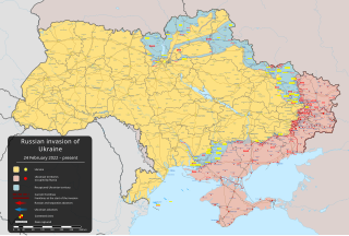
English: پر اوکراین د روسیې د ۲۰۲۲ ز کال یرغل – ongoing military conflict in Eastern Europe since 2022 [] |
||
| نېټه | ۲۴ فبروري ۲۰۲۲ (first version) | ||
| سرچينه |
Own work based on: Russo-Ukrainian conflict (2014-2022).svg by Rr016 & Ukraine adm location map improved.svg by Yakiv Gluck
|
||
| ليکوال | Viewsridge | ||
| نورې بڼې |
[]
|
||
| SVG genesis | This map is translated using SVG switch elements: all translations are stored in the same file.
|


.gif)

.gif)


_en.png)
_vi.png)
_ru.png)
.svg)
This file is translated using SVG <switch> elements. All translations are stored in the same file! Learn more.
For most Wikipedia projects, you can embed the file normally (without a To translate the text into your language, you can use the SVG Translate tool. Alternatively, you can download the file to your computer, add your translations using whatever software you're familiar with, and re-upload it with the same name. You will find help in Graphics Lab if you're not sure how to do this. |
منښتليک:
- تاسې کولی شئ چې:
- بيا يې د نورو سره شريک کړئ – همدا اثر ولمېسئ، و وېشئ او بيا يې خپور کړئ
- بيا ادلون بدلون راولئ – بدل شوی اثر خپل کړئ
- د لاندې شرطونو له مخې:
- اړوندېدنه – تاسې بايد دا اثر د ليکوال يا منښتگر لخوا د ځانگړو شويو اصولو سره اړونده وگڼئ (خو په دې توگه نه چې داسې ښکاره شي چې گنې تاسې يا ستاسې لخوا کارېدنه د اثر د ملاتړ سبب شوی)
- يوشان شريکول – که تاسې همدا اثر بدلوئ، رغوئ، او يا يې هم سر له نوي جوړوئ نو په پايله کې رامېنځ ته شوی اثر به يوازې د همدې دوتنې ورته منښتليک پر بنسټ خپروئ.
د دوتنې پېښليک
په يوې نېټې/يوه وخت وټوکۍ چې د هماغه وخت او نېټې دوتنه چې څنگه ښکارېده هماغسې درښکاره شي.
| نېټه/وخت | بټنوک | ډډې | کارن | تبصره | |
|---|---|---|---|---|---|
| اوسنی | ۲۰:۴۷, ۱۶ مې ۲۰۲۴ | | ۲٬۱۹۹ × ۱٬۴۷۸ (۳٫۷۲ مېگابايټ) | Physeters | Updates in Kharkiv Oblast per the ISW |
| ۰۴:۴۰, ۱۴ مې ۲۰۲۴ |  | ۲٬۱۹۹ × ۱٬۴۷۸ (۳٫۷۲ مېگابايټ) | Physeters | fix Derhachi | |
| ۰۵:۳۶, ۱۳ مې ۲۰۲۴ |  | ۲٬۱۹۹ × ۱٬۴۷۸ (۳٫۷۲ مېگابايټ) | Alexiscoutinho | Updated Vovchansk per detailed map | |
| ۰۲:۴۹, ۱۳ مې ۲۰۲۴ |  | ۲٬۱۹۹ × ۱٬۴۷۸ (۳٫۷۲ مېگابايټ) | Physeters | Updates per the ISW; for future reference, sources (like SuriyakMaps) must first have their reliability vetted on the talk page before they can be used to update the map; at the moment, the only two verified sources are the ISW and the Detailed Map on Wikipedia | |
| ۱۰:۳۴, ۱۲ مې ۲۰۲۴ |  | ۲٬۱۹۹ × ۱٬۴۷۸ (۳٫۳۱ مېگابايټ) | BlackShadowG | File uploaded using svgtranslate tool (https://svgtranslate.toolforge.org/). Added translation for zh-tw. | |
| ۰۸:۴۶, ۱۲ مې ۲۰۲۴ |  | ۲٬۱۹۹ × ۱٬۴۷۸ (۳٫۳۱ مېگابايټ) | Miki1234568 | File uploaded using svgtranslate tool (https://svgtranslate.toolforge.org/). Added translation for pl. | |
| ۰۷:۵۴, ۱۲ مې ۲۰۲۴ |  | ۲٬۱۹۹ × ۱٬۴۷۸ (۳٫۳۱ مېگابايټ) | BlackShadowG | File uploaded using svgtranslate tool (https://svgtranslate.toolforge.org/). Added translation for zh-cn. | |
| ۲۳:۰۲, ۱۱ مې ۲۰۲۴ |  | ۲٬۱۹۹ × ۱٬۴۷۸ (۳٫۷۱ مېگابايټ) | Mattia332 | As per Renowned Unbiased Open Source "SuriyakMaps", Russian progress in Kharkov | |
| ۱۹:۳۸, ۱۰ مې ۲۰۲۴ |  | ۲٬۱۹۹ × ۱٬۴۷۸ (۳٫۷۱ مېگابايټ) | Physeters | add date marker | |
| ۱۹:۳۱, ۱۰ مې ۲۰۲۴ |  | ۲٬۱۹۹ × ۱٬۴۷۸ (۳٫۷۱ مېگابايټ) | Physeters | Update per the ISW; Russia re-enters northern Kharkiv Oblast |
د دوتنې کارېدنه
دا لاندينی مخ د همدې دوتنې سره تړنې لري:
د نړېوالې دوتنې کارېدنه
همدا دوتنه لاندينۍ نورې ويکي گانې کاروي:
- په af.wikipedia.org کارونې
- په als.wikipedia.org کارونې
- په am.wikipedia.org کارونې
- په ang.wikipedia.org کارونې
- په an.wikipedia.org کارونې
- په ar.wikipedia.org کارونې
- په ary.wikipedia.org کارونې
- په arz.wikipedia.org کارونې
- په ast.wikipedia.org کارونې
- په azb.wikipedia.org کارونې
- په az.wikipedia.org کارونې
- په bat-smg.wikipedia.org کارونې
- په bcl.wikipedia.org کارونې
- په be-tarask.wikipedia.org کارونې
- په be.wikipedia.org کارونې
- په bg.wikipedia.org کارونې
- په bh.wikipedia.org کارونې
- په bn.wikipedia.org کارونې
- په br.wikipedia.org کارونې
- په bs.wikipedia.org کارونې
- په bxr.wikipedia.org کارونې
د دې دوتنې نورې نړېوالې کارېدنې کتل.